- Hays County emergency alerts cause confusion during Tuesday's wildfires
- Tuesday's wildfires scorched more than 500 acres in south Bexar County
- How big were this week's wildfires in Bexar County?
- Crews contain wildfire in southeast Williamson County
- Wildfire contained to 300 acres in northwest Matagorda County
Steady rain continues in the Triangle; Tornado Watch still in effect for central NC

Parts of Central North Carolina remain under a Tornado Watch until 11 p.m. on Thursday.
Cumberland, Hoke, Sampson, and Wayne Counties are included in the Tornado Watch.
WRAL meteorologist Kat Campbell said the highest potential for tornado activity was earlier in the day for Cumberland County. The highest tornado potential through the early evening was for areas in Sampson County, Wayne County and southern Johnston County until around 8 p.m.
“There is still a chance of a tornado, across the southeastern part of our viewing area, the highest risk of that this evening will be for the southern part of Sampson County and potentially Wayne County as well,” Campbell said during the 7 p.m. WRAL News.
Campbell said the risk for tornadoes will start to decrease after 10 p.m. Thursday.
Earlier Thursday afternoon, there was a Tornado Warning issued for parts of South Carolina, near the Florence area. Another warning was issued for Pamlico County on the coast. Both have since been canceled.
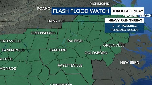
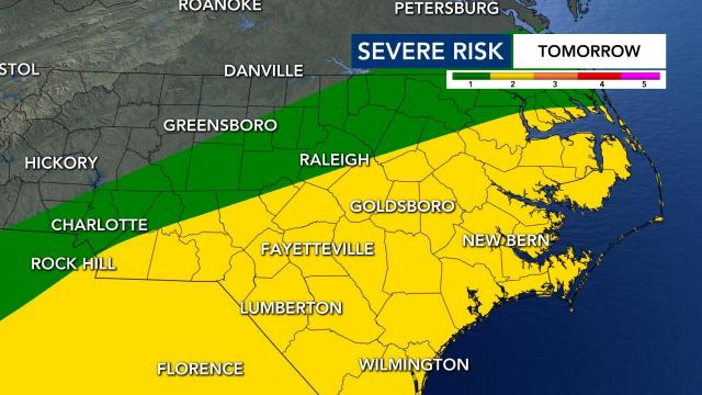
Much of the state was also under a flash flood watch and a Level 2 risk for severe storms on Thursday and into Friday evening.
Areas around central North Carolina have received an abundance of rain but no threats of flooding have been seen through late Thursday evening. Places like Lake Gaston (2.79 inches of rain in the past 24 hours), Pinehurts (2.5 inches) and Warrenton (2.72) have registered the most amounts of rain in the central N.C. region.
Remnants from Sally are bringing us excessive rainfall and flooding. Rain will be possible all day on Thursday and Friday. WRAL’s Severe Weather team says to expect the heaviest rain on Thursday afternoon and evening.
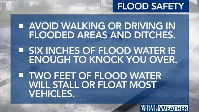
If you are driving on Thursday evening, be aware of flooded roads, which can be deadly. Do not try to drive through standing water or washed out roads.
Earlier this month, two young children riding in their mother’s car in Smithfield died when the car was swept away in floodwaters. Eight inches of rain was reported in the area. Their bodies were found days later in a shallow creek near the Neuse River.
Sally has been downgraded to a tropical depression. The storm made landfall in Alabama at around 6 a.m. on Wednesday as a Category 2 storm. The remains of Sally will cause a remnant low south of North Carolina.
Heavy rains and saturated ground trees could come down and power outages are possible on Thursday and Friday. Wind gusts are expected to pick up to 20 to 30 mph, which could also knock over trees.
Flooding risk
WRAL meteorologist Elizabeth Gardner said the number one risk for Thursday is flooding.
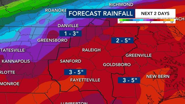
The Triangle is expecting 2 to 5 inches in the next two days from these storms.
“There are going to be places that don’t see flooding and there are going to be places that do,” said Gardner.
Minor river flooding is also forecast for several area rivers.
City of Raleigh officials said that flooding is possible on the Capital Area Greenway System. Officials said to not attempt to cross flood waters covering any part of the Greenway.
Slowdown if you come across asphalt, concrete or wooden bridges that are flooded.
The flash flood watch expires at 11 a.m. on Friday.
Level 2 risk for severe weather
The highest risk for severe weather is under the center of circulation.
Storms rolling in on Thursday could cause damaging wind gusts from faster moving bands of rain and tropical downbursts. There is also the chance of a weak tornado or two. The chance for tornados is low, according to WRAL meteorologist Zach Maloch.
Thunderstorms should move out of our area by Friday night.
NC prepares for storms
Wake County’s free coronavirus testing site at the Sunnybrook parking deck will close at noon on Thursday ahead of storms.
Anyone who has a scheduled appointment can come back at any time on Friday to get tested for the coronavirus.
Governor Roy Cooper will talk about the soaking rain and flooding risks North Carolina is facing in a press conference on Thursday at 3 p.m.
The state already had national guardsmen and swift water rescue teams on standby.
