- Austin adopts new map that greatly expands area at risk of wildfire
- CenterPoint Energy accelerates infrastructure improvements ahead of hurricane season
- Carolina Hurricanes playoff tickets go on sale Thursday
- Ask the Meteorologist: Why do tornadoes target Tornado Alley, Dixie Alley?
- Nonprofit closes distribution site that aided thousands after Hurricane Helene
Beta downgraded to a tropical depression, Flash Flood Warning continues for parts of Houston area
Ongoing high water spots are expected throughout the day Tuesday after Beta made landfall on the Texas coast last night.
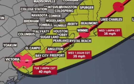
HOUSTON — Tropical Storm Beta made landfall Monday around 10 p.m. near the southern end of the Matagorda Bay Peninsula with sustained winds of 45 mph.
As of 10 a.m. Tuesday, Beta was downgraded to a tropical depression, but the flood threat remains for Southeast Texas for at least the next 24 hours.
Beta was nearly stationary (now moving northeast at only 2 mph) with winds at 35 mph. It is now expected to head east-northeast, moving slowly over Matagorda and Brazoria counties moving slowly up the Texas coast and through the Houston area, weakening to a tropical depression by late Tuesday night.
HIGH WATER LIST: Flooding reported on Houston-area roads
PHOTOS & VIDEO: Street flooding in Houston and Galveston areas
SCHOOL CLOSURES: Some closed, others going to online learning
Street flooding will continue to be the greatest threat Tuesday and early Wednesday in Houston.
In some areas we have received between 7-11 inches of rain in 24 hours. Flooding inland shifted from our coastal areas last night and is a continued threat through Harris County today.
WEATHER ALERTS:
Rain will continue to sweep in across the Houston Galveston area all day Tuesday and for a portion of Wednesday. A Flash Food Watch is in effect for the entire area.
Where is Tropical Storm Beta going?
The storm is made landfall Monday night near the southern end of the Matagorda Peninsula. Once inland, the storm is expected to move northeast along the coast through Wednesday, becoming a depression by the time it reaches Houston.
By early Wednesday afternoon, Beta will be out of the Houston area and over Beaumont and entering Louisiana.
What can Houston and Southeast Texas expect?
Periods of fast moving, heavy rain are expected to continue Tuesday, regardless if Beta is a tropical storm or a tropical depression. Flooding in low-lying areas is the greatest threat with this system so far.
At this time we are not expecting widespread structural flooding issues across our inland communities, but we are watching our bayous closely. It is best to stay home Tuesday if you can as many cars have been flooded already.
Our primary concern with this system will be isolated spots of street flooding during those heavy downpours and flooding/storm surge in our coastal communities.
Interactive tropical tracker map
Additional rainfall amounts expected Tuesday and Wednesday
National Hurricane Center Tuesday morning update
1. Significant flash and urban flooding is occurring and will continue for the middle and upper Texas coast today. The slow motion of Beta will continue to produce a long duration rainfall event from the middle Texas coast to southern Louisiana. Flash, urban, and minor river flooding is likely. Periods of rainfall will continue into the ArkLaTex region and spread east into the Lower Mississippi Valley and portions of the Southeast through the end of the week. Flash, urban, and isolated minor river flooding is possible.
2. Storm surge flooding will continue throughout the morning, around the times of high tide along portions of the Texas coast within the storm surge warning areas. Residents in these areas should continue to follow advice of local officials.
3. Tropical-storm-force winds will continue near portions of the Texas coast within the warning area today.