- David & Nicole Tepper increase Hurricane Helene relief commitment to $750k
- McDowell County wildfire spreads to 500 acres, evacuation orders in place
- Evacuations in Caldwell County due to wildfire
- Northwest Houston 'ghost neighborhood' caused by repeated flooding to become latest detention basin
- NHL playoffs: Hurricanes open playoffs Easter Sunday afternoon vs. Devils
Tropical Storm Beta makes landfall near Port O'Connor, TX
While Central Texas is not in the direct path, local impacts are expected.
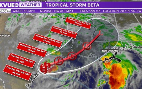
AUSTIN, Texas — Tropical Storm Beta made landfall near Port O’Connor late Monday night around 10 pm. This is the ninth named storm that has made landfall in the continental U.S. this year which means 2020 is officially tied with the 1916 hurricane season for the most continental U.S. landfalls in a single season.
Beta is the second system named with the Greek alphabet in 2020. This is the second time in history that the Greek alphabet has been used to name tropical systems.
Beta has weakened and now has maximum sustained winds of 45 mph. The storm is moving northwest at 5 mph. Rain bands will continue to move onshore with the heaviest of the rain expected across the middle Texas coast but rain bands will continue to push through Central Texas Tuesday.
Beta’s latest forecast track shows that it’s expected to stall along or just inland from the coast during the 12 to 24-hour period. A weak trough to the west will finally help nudge Beta east-northeastward on Tuesday afternoon.
The sharp turn to the northeast keeps the highest rainfall totals southeast of Austin.
The Hill Country could receive up to one-and-a-half inches of rain. The Interstate 35 corridor counties can expect between one to two inches of rain with locally higher totals. Areas southeast and east of I-35 could see upward of two inches of rain.
The latest Beta track keeps the KVUE viewing area on the left-hand side of the track. This lowers the severe weather threat for Austin and Central Texas. Areas in southeast Texas will have to watch for heavy rain, strong winds and tornadic activity in the next two days.
In fact, Fayette County is included in a Flash Flood Watch through Tuesday evening.
Austin weather: How will Beta affect Central Texas?
In Austin and the rest of Central Texas, you can expect:
1. Heavy rain at times, but mostly scattered showers. Highest rain totals were southeast of Austin.
2. Wind gusts can be near 20 to 30 mph on Monday and Tuesday.
3. Cloud cover and rain keeps temperatures in the 70s on Monday.
Stay tuned for the latest updates from the KVUE Storm team. For live weather alerts, download the KVUE app at kvue.com/app. Also be sure to follow KVUE on YouTube, Twitter, Facebook and Instagram.
PEOPLE ARE ALSO READING: