- Tuesday's wildfires scorched more than 500 acres in south Bexar County
- How big were this week's wildfires in Bexar County?
- Crews contain wildfire in southeast Williamson County
- Wildfire contained to 300 acres in northwest Matagorda County
- Bill would make it easier for homeowners to afford upgrades to protect from storm damage
TROPICAL STORM: Tracking Beta as it makes landfall on Texas Coast
Rain bands have been moving through South-Central Texas overnight and should continue throughout Tuesday.
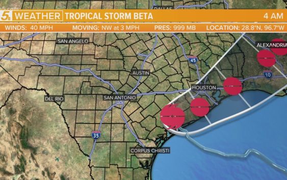
SAN ANTONIO — Tropical Storm Beta made landfall around 10 p.m. Monday night along the middle Texas Coast. The storm should stall inland today before moving to the northeast Wednesday, the National Weather Service says.
Rain bands have been moving through South-Central Texas overnight and should continue throughout Tuesday.
A Tropical Storm Warning and Flash Flood Watch remain in effect for Lavaca and DeWitt Counties. Two to four inches of locally heavy rainfall and wind gusts up to 40 mph are possible across these areas. Moderate rainfall and wind gusts up to 30 mph could reach as far as Interstate 35.
Governor Greg Abbott issued a Disaster Declaration Monday for 29 Texas counties in response to Tropical Storm Beta, including Bexar.
Counties included in this Disaster Declaration include Aransas, Bee, Bexar, Brazoria, Calhoun, Chambers, Fort Bend, Galveston, Hardin, Harris, Jackson, Jasper, Jefferson, Jim Wells, Kenedy, Kleberg, Liberty, Live Oak, Matagorda, Nueces, Orange, Refugio, Sabine, San Augustine, San Patricio, Shelby, Travis, Victoria, and Wharton.
“As Tropical Storm Beta approaches the coast, I urge Texans in the path of the storm to remain vigilant and take necessary precautions to keep themselves and their loved ones safe from flooding, storm surge, and other impacts from this severe weather,” said Governor Abbott.
The National Hurricane Center’s trajectory forecast for the storm moved further south, and said the storm could weaken more quickly than originally expected.
“Due to the slow motion of the storm, the primary hazards remain heavy rainfall, large and dangerous swells, and significant coastal flooding,” said the National Weather Service in an update Sunday night.
Beta was the third system to get a name in seven hours on Friday, the first time three storms have ever been named in a day.
Wilfred formed in the Atlantic this week, which means we have officially run out of the”regular” 2020 Atlantic season hurricane names, and we will now continue on to the Greek alphabet. A short time later, Subtropical Storm Alpha formed near the coast of Portugal.
The storm is expected to make the most serious impact in the Houston area with heavy rain and storm surge, but the exact track is still unclear and the rainfall totals are difficult to predict.
Get the last weather news straight to your phone. You can download it in the App Store or Google Play. Also be sure to follow KENS 5 on Facebook, YouTube, Twitter and Instagram for updates on the weather.
Follow the KENS 5 Weather Team