- National memorial to honor NC firefighter who died on duty during Hurricane Helene
- Gov. Josh Stein extends State of Emergency for western NC wildfires
- Gov. Stein extends state of emergency for NC wildfire threat
- Governor Stein extends state of emergency for NC wildfire threat
- Governor Stein extends emergency in 34 NC counties amid wildfire threat
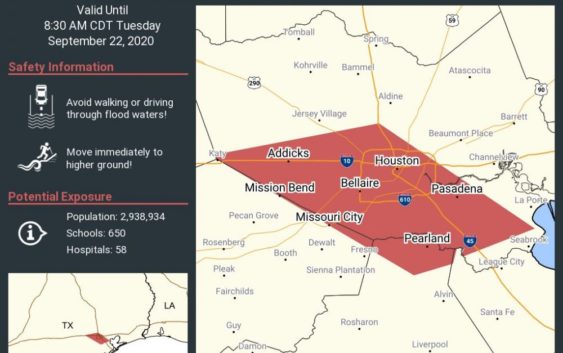
Update: Tropical Storm Beta Weakens To Tropical Depression, Stalls Over Texas Coast
Updated 2:54 p.m. CT
Beta weakened to a tropical depression Tuesday as it parked itself over the Texas coast, raising concerns of extensive flooding in Houston and areas farther inland.
Beta made landfall late Monday as a tropical storm just north of Port O’Connor, Texas, and has the distinction of being the first time a storm named for a Greek letter made landfall in the continental United States. Forecasters ran out of traditional storm names last week, forcing the use of the Greek alphabet for only the second time since the 1950s.
By mid-morning Tuesday, Beta was 15 miles east-northeast of Victoria, with maximum sustained winds of 35 mph, the U.S. National Hurricane Center said. The storm was moving toward the northeast at 2 mph and is expected to stall inland over Texas through Wednesday.
The National Weather Service said areas south and east of Houston had already seen 10 inches or more of rain by midday Tuesday because of Beta.
Street flooding was reported in parts of Houston, but there were no reports of buildings being flooded, Mayor Sylvester Turner said late Tuesday morning. Turner urged residents to stay home and, if they couldn’t, to not drive around the 70-some barricades placed throughout the city.
“It’s going to be moving very slowly heading east and until it clears and gets on the east side of Houston, we’re going to have to deal with these rain bands,” Turner said.
Houston Fire Chief Sam Peña said the department had made more than 60 rescues from vehicles before noon, most from vehicles stalled in the roads due to street-level flooding.
Most of those came from the south and southwest portions of the city, where rainfall totals had already reached more than a foot in some areas.
Turner told Houston residents to expect heavy rain throughout the day Tuesday, and urged people not to drive through high water.
“You could possibly drown,” Turner said at a press conference Tuesday. “If not, at very minimum you could stall. And your’re just gonna create problems for yourself, and then the first responders are gonna be out there doing our best to rescue you.”
As of Tuesday afternoon, White Oak, Brays and Buffalo bayous were all nearing overflow.
Harris County Judge Lina Hidalgo on Tuesday told residents that a new band of rain forming before the storm moves away could cause flooding to structures in the coming days.
“The next 24 hours will not be business as usual in Harris County,” Hidalgo said. “The threat is not gone, until at least (Wednesday) around noon.”
White Oak Bayou, left, and Brays Bayou, both near full Tuesday. Photos by (@pauldebenedetto and @krbuckle) https://t.co/ALCkUn9IMv pic.twitter.com/gI8bhFUyN1
— Houston Public Media (@HoustonPubMedia) September 22, 2020
Beta was the ninth named storm that made landfall in the continental U.S. this year. That tied a record set in 1916, according to Colorado State University hurricane researcher Phil Klotzbach.
Beta was expected to eventually move over Louisiana, Arkansas and Mississippi later in the week, bringing the risk of flash flooding.