- Tuesday's wildfires scorched more than 500 acres in south Bexar County
- How big were this week's wildfires in Bexar County?
- Crews contain wildfire in southeast Williamson County
- Wildfire contained to 300 acres in northwest Matagorda County
- Bill would make it easier for homeowners to afford upgrades to protect from storm damage
Level 1 Risk of Severe Weather for Parts of NC on Sunday
RALEIGH, N.C. (WTVD) — Tropical Depression Delta will represent the most impactful aspect of the forecast, but the good news is that the heaviest rains will likely be to the north of the viewing area as Delta approaches tomorrow.
The rain this evening is only loosely associated with Delta and can be attributed mostly to a warm front lifting northward ahead of Delta will also be moving quickly enough to keep the flood risk relatively low. That’s not to say there can’t be any isolated flooding, but it will likely be that, isolated.
The rain this evening is only loosely associated with Delta and can be attributed mostly to a warm front lifting northward ahead of Delta will also be moving quickly enough to keep the flood risk relatively low. That’s not to say there can’t be any isolated flooding, but it will likely be that, isolated.
Level 1/5 risk of severe weather tomorrow for areas south of the Triangle. Main threat is a damaging wind gust however an isolated tornado cannot be ruled out. Stay weather aware with the ABC11 app throughout the day tomorrow. #ncwx pic.twitter.com/CFmfCevuff
— Robert Johnson (@RobJohnsonABC11) October 10, 2020
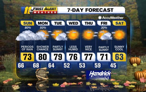
Total rainfall amounts tonight through Sunday evening of 0.50-1.00 inches will be common with some locations, particularly north of the Triangle, picking up close to 1.50 inches. Drier air will filter in later Sunday night with only a stray shower remaining for Monday. After a cloudy couple of days, the sun returns for Tuesday and Wednesday with a mix of clouds and sun. Tuesday looks to the warmest day of the week with temperatures in the lower 80s which is about 10 degrees above average for this time of year.
A moisture-starved cold front will make its way through Tuesday night or Wednesday. There is a slight chance of a shower or thunderstorm as this front passes, but it is expected that this front will probably do nothing more than cool temps down for late week. Another cold front will approach the area Thursday night into Friday.
Be Well & Stay Safe!
Robert Johnson
Copyright © 2020 WTVD-TV. All Rights Reserved.