- Trump makes more debunked claims about FEMA as he surveys storm damage in North Carolina
- Hundreds rescued, sheriff stranded on truck roof after deadly flooding in New Mexico
- In North Carolina, Trump and Harris navigate a hurricane and a rollercoaster governor’s race
- In North Carolina, Trump and Harris navigate a hurricane and a rollercoaster governor's race
- Family of Tennessee employee who died in Hurricane Helene flooding files wrongful death lawsuit
Tropical Storm Zeta arrives in the Carolinas

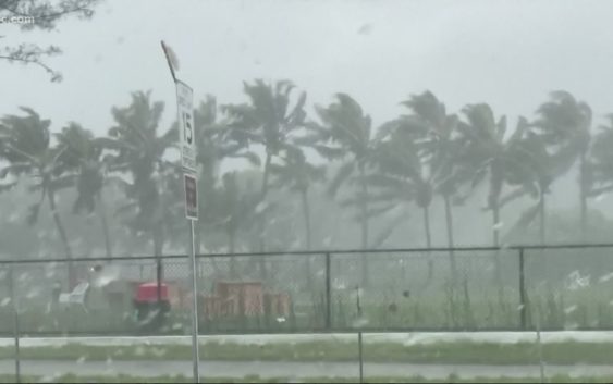
Gusty, tropical storm-force winds are toppling trees and bringing down powerlines.
CHARLOTTE, N.C. — Thousands are without power in the Carolinas as Tropical Storm Zeta brings gusty winds to the region Thursday. Additionally, the storm brings a threat of heavy rains, localized flooding, and isolated tornadoes.
A Tropical Storm Warning is in effect Charlotte, across Mecklenburg County, and for counties all along the I-85 corridor. A Tropical Storm Warning means tropical-storm-force winds over greater than 39 mph are highly likely or already occurring.
Sustained winds up to 40 mph possible, with higher gusts, are expected along and north of the Interstate 85 corridor from upstate South Carolina, through Charlotte, and northward to Greensboro. Some wind gusts could easily surpass 50 mph.
The North Carolina mountains have the highest risk of flooding, with 4-6 inches of rain expected and some areas could see even higher totals. In Charlotte, the First Warn Storm Team expects up to 2 inches of rain.
“The main threat for flash flooding would be anywhere from Burke County, Caldwell County, all the way up to Ashe, Avery, and Watauga County,” said First Warn’s Larry Sprinkle.
School districts across the area responded to the severe weather threat with choices to move to virtual learning for Thursday, with some closures as well.
Zeta’s strong winds, heavy rains leave hundreds of thousands without power in Georgia
As of 6 a.m. Thursday, Zeta has left nearly 500,000 people in metro Atlanta without power as the storm moves northeast toward the Carolinas.
Across upstate South Carolina, more than 100,000 Duke Energy customers lost power Thursday morning.
As gusty winds arrived later Thursday morning, additional outages were being reported in Charlotte, along the I-77 corridor, and in the western North Carolina mountains and foothills.
Zeta’s Louisiana landfall
Zeta made landfall along the Louisiana coast south of New Orleans Wednesday as a very strong category 2. Within 110 mph sustained winds at landfall, Zeta needed only one mph stronger winds to be formally classified as a ‘major hurricane’ as a category 3.
The tropical storm system is expected to maintain tropical storm strength as it moves quickly across the Southeast and through the Carolinas Thursday.
Wind impacts from Zeta in the Carolinas
Morganton, Hickory, Lincolnton, Statesville, and Gastonia could be among the areas that see 30 to 40 mph sustained winds with gusts up to 50 mph.
Higher, mountain elevations near Boone and Blowing Rock could see sustained winds of 25 – 35 mph with gusts up to 45 mph.
South of Interstate 85, including the City of Charlotte, Rock Hill, and Fort Mill, could see winds of 30 mph with gusts up to 40 mph.
As a result, power outages and down trees will occur as Zeta impacts the region a Thursday.
Strong winds are expected to diminish throughout the afternoon as the center of Zeta’s circulation moves east of Interstate 77.
Rain and flooding impacts from Zeta in the Carolinas
Zeta is forecast to bring 3 – 4 inches of rain to the higher elevations in the North Carolina mountains, including in Avery, Ashe, and Watauga counties. Rainfall totals decrease with elevation with 2 to 3 inches expected near Lenoir. Across the foothills and mountains, the National Weather Service has issued a Flash Flood Watch, which means flash flooding could occur over the next day.
In other parts of the foothills and piedmont, 1.5 to 2 inches of rain could be observed in Hickory, and upwards of one inch in Charlotte.
Although a tropical storm watch has not been issued for counties such as Mecklenburg, Avery, Ashe and Watauga, residents should monitor changing weather conditions over the next few days.
Tornado impact from Zeta in the Carolinas
And while Zeta’s strongest winds and highest rainfall rates are expected in the higher elevations of the Carolinas west of Interstate 77, there is a low risk potential for severe weather along the Interstate 77 and Instate 85 corridors Thursday.
Cities like Charlotte, Statesville, Columbia, and Greenville, could see an isolated tornado risk early Thursday morning through Thursday afternoon.
Across the Southeast and Carolinas, residents are encouraged to charge batteries, phones, and radios ahead of Zeta. Scattered power outages are possible Thursday.
Preparing your homes
Arborists say there are two key factors homeowners should consider preparing for the high winds—checking the ground saturation and making sure large you tree canopies have enough space to allow air to move through and prevent a strain on the tree root.
“It may present as a fully healthy tree, fully leafed out but it’s that full weight that can aid in that tree uprooting,” ISA certified arborist Joshua Milbourne said.
With the potential for falling trees, Duke Energy says it’s also prepared for any possible power outages too.
“We have more than 2500 crews here in the Carolina that are here to respond to outages and emergencies if they occur,” Duke Energy spokesperson Meghan Miles said.
In addition, there are nearly 300 workers on standby from Duke’s Midwest territories as well if more help is needed. As for a potential flooding threat, Duke Energy has also lowered the lake level to accommodate the extra rainfall.
Stay informed of severe weather alerts
The WCNC Charlotte First Warn Storm Team will be monitoring weather conditions throughout Zeta. Download the WCNC Charlotte mobile news app to enable severe weather notifications for your location.
WCNC Charlotte encourages you to have multiple ways to receive severe weather notifications including our app, a NOAA weather radio, and access to television and radio broadcasts.