- Some in Hurricane Helene-ravaged North Carolina embrace Pres. Trump’s push to abolish FEMA
- Homes destroyed: Western NC families battling insurance disputes after Hurricane Helene
- Freezing weather, wildfire and flood risk forecast across Texas
- ‘Life-threatening cold’ expected as polar vortex stretches across U.S. after deadly weekend flooding
- Some in Hurricane Helene-ravaged North Carolina embrace Trump's push to abolish FEMA
Flash Flood Warning issued as rain moves through Charlotte area
Heavy rain is expected at times with some areas potentially seeing four inches of rain.
CHARLOTTE, N.C. — The First Warn Storm Team is tracking heavy rain moving through the Charlotte area going into Thursday. A Flash Flood Watch was issued on Wednesday and is in effect until 7 p.m. Thursday for much of the area.
WCNC Charlotte Chief Meteorologist Brad Panovich said you can expect the worst of the rain through around noon on Thursday.
Severe weather issues include a few gusty winds and potential flooding in some areas. Thunderstorms are also expected late Wednesday night and into Thursday morning.
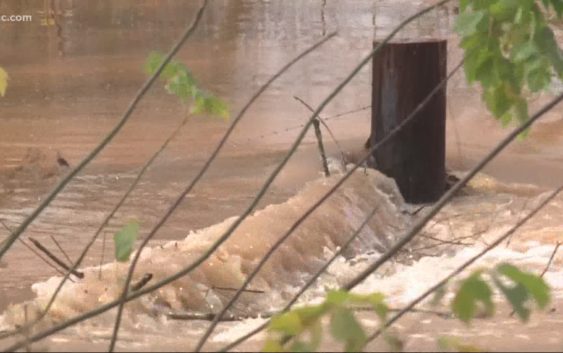
Morning rainfall moved in and out of Lincoln County, leading to Howards Creek swelling beyond its banks. It overtook the tops of fences and spilled out onto land where cattle used to stand along Daniels Road.
Areas west of Charlotte could see 5-7 inches of rain. The Charlotte area could see between 3-4 inches of rain over the same time period.
Meteorologist Chris Mulcahy spent the morning in the Chevy Storm Tracker. During a ride through Gaston County, he reported on and off showers that were heavy at times along Interstate 85.
RELATED: FORECAST: More heavy rain overnight
“There’s going to be some rain and there’s going to be some breaks and that’s going to be the general forecast so we can classify it as scattered rain, but at times it is going to be widespread,” Mulcahy said.
Mulcahy warned streets may be slick due to oils on the surface of the roads as well as the wet leaves on some of the back roads. As rain starts to pool on the roads, there is the potential for hydroplaning as well.
Along Reepsville Road at Seagletown Road, Debra Pardo saw a similar sight outside her window Wednesday morning.
“Rushing waters from there all the way across the street, and it was crazy,” Pardo said.
The water in a creek off Reepsville Road rose quickly, almost spilling out onto the road in front of her house.
“I said, ‘Whoa,’ cause we didn’t know what to think,” Pardo said. “Cause we didn’t realize it had rained that much.”
It’s scenes like the ones in Lincoln County that have the National Weather Service warning people about flash flooding. They urge people to get to higher ground, avoid driving into water, and stay informed for local weather updates.
Lincoln County is projected to see some of the highest rainfall totals in the Charlotte area by the end of the day Wednesday, and it has people in Lincoln County who live near the full creeks on alert to see what happens next.
“Thank goodness mine’s high up,” Pardo said about her house. “If it does come to the street, it probably won’t come this far.”