- Sellers and Rantanen are among the NHL trade deadline winners. Hurricanes and Boeser are some losers
- Hurricane forecasters express concern over NOAA job cuts impact
- FEMA deadline for Hurricane Helene recovery aid extended again
- Tornado drills to take place at schools across North Carolina Friday morning
- Hays County emergency alerts cause confusion during Tuesday's wildfires
Severe thunderstorms march east across NC; tornadoes possible through 10 p.m.
Raleigh, N.C. — The Triangle saw gusty winds and downpours through mid-day on Christmas Eve, while tornado warnings popped up to the south. Just after 4 p.m., nine counties were under severe weather alert warnings.
Much of the eastern half of the state, including Wake and Johnston counties, is under a tornado watch – which means conditions are right for tornadoes to form – through 10 p.m.
At 4 p.m., tornado warnings covered parts Bladen, Edgecombe, Johnston, Nash, Wayne, Wilson, Cumberland and Sampson counties. By 4:30 p.m., those warnings were reduced to severe thunderstorm warnings.
“That means severe weather is imminent or occurring and you need to get to your safe place,” said WRAL meteorologist Kat Campbell.
Warnings began before 3 p.m., when rotation was detected by radar near Clinton. Wanrings were issued and allowed to cancel as the line of storms progressed and changed.
By 3:30 p.m., the National Weather Service spotted a severe thunderstorm capable of producing a tornado
located 11 miles north of Clinton, moving northeast at 40 mph.
Residents of Salemburg in Sampson County reported heavy downpours and flash flooding. Heavy rain was also falling along and east of Interstate 95.
“Showers and storms likely through at least 11 p.m., with some being strong to severe,” WRAL meteorologist Mike Maze said.
Multiple counties, including Johnston, Cumberland, Wayne, Wilson and Nash, are also under a wind advisory until 1 a.m. on Friday. Winds of 15 to 20 mph, with gusts up to 45 mph are expected.
Greatest severe weather risks
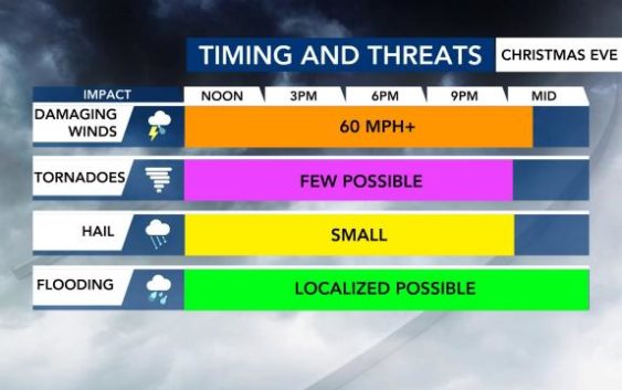
Maze says the greatest threat for the Triangle will be damaging wind gusts greater than 60 mph during the storms and “supercells,” or rotating thunderstorms.
To the south and east of the Triangle, the potential for tornadoes is greater. During the noon hour, tornado warnings were issued in Robeson and Bladen counties, but no damage was reported.

Localized flooding is also possible as heavy rain is forecast to fall into the evening.
Bitter cold air for Christmas morning
A second line of storms, expected to cross North Carolina late Thursday night, will usher in much colder temperatures. Overnight on Christmas Eve, temperatures will drop across the Triangle from the mid-60s to the mid-30s.
“Once the cold front passes at around midnight, we should see the temperatures drop, the air stabilize and then just rain is expected until close to daybreak,” said WRAL meteorologist Kat Campbell.
In central North Carolina, the high on Christmas Day will reach only about 40 degrees, with wind chills that make it feel like the 20s, Maze said.
The cold continues into the weekend, with Friday’s overnight low dipping below 20 degrees.
Saturday and Sunday will be cold and clear, with temperatures gradually climbing back to more normal daytime highs in the 50s.
WRAL Night of Lights canceled for Christmas Eve
With heavy rain and gusty winds in the forecast, WRAL and the City of Raleigh have canceled the Christmas Eve viewing of Nights of Lights at Dorothea Dix Park.
The drive-thru light show will be suspended to keep workers and visitors from the danger of high winds.
Anyone with a ticket for Nights of Lights on Dec. 24 will get an email assigning them to another time slot on another night.
Ticketholders also have the option to request a refund at any time for any reason.

Like Christmas, the weekend will be very cold, with highs in the mid 40s. Chances are very slim for snow, even with the cold weather temperatures.