- Report: Coastal flooding could threaten 1.4 million homes by midcentury
- Caught on camera | Tornado touches down in Missouri
- Carolina Hurricanes playoff tickets go on sale next week
- Storms kill 6 in the South and Midwest as forecasters warn of catastrophic rains, floods this week
- Weather Impact Alert: Cold front could trigger severe weather in Houston area this weekend | See timeline
Tornado Watch issued for eastern counties in central NC

Mother Nature is putting some coal in our stockings with this Christmas Eve forecast.
We will see a significant system swing through this afternoon and evening.
Ahead of it, the warm air will surge into North Carolina and we get temps that are 15 to 20 degrees above average. It won’t be a record (the warmest Christmas Eve ever was in 2015 at 77), but if we make our forecast high of 67, it would put us in the 10 warmest Christmas Eve highs on record.
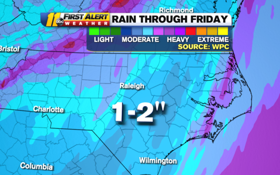
And with all that warm air in place, the atmosphere will be primed to see a nasty line of showers of thunderstorms on Thursday afternoon into Thursday evening. The biggest threat from these storms would be damaging winds. We could see gusts in excess of 50mph. That, along with a soft ground from over an inch of rain, will be enough to bring down powerlines in spots, and cause some Christmas Eve power outages.
On Wednesday, the National Weather Service increased the severe threat to a slight, 2 out 5, for most of the area and an enhanced risk, level 3 out of 5, along and east of I-95.
The @NWSSPC increased the severe risk to Cat 3 of 5 for the eastern part of the viewing area. Biggest threat still damaging winds, but an increased chance of an isolated tornado spinning up. Please be #WeatherAware today! #ncwx pic.twitter.com/NtZodV8Op9
— 𝘿𝙤𝙣 𝙎𝙘𝙝𝙬𝙚𝙣𝙣𝙚𝙠𝙚𝙧 (@BigweatherABC11) December 24, 2020
There’s also a 10% chance of an isolated tornado spinning up. That threat is highest along and east of the I-95 corridor. That may not sound like much, but if I said to you on an airplane “This flight has a 10% chance of crashing,” you might think twice about flying.
Just be sure to stay weather aware today. We will be watching the system and getting a better idea of the timing on its arrival throughout the day.
The other big part of this system is the cold air that plunges in on Thursday night. On Christmas Day the highs will stay in the 30s and the wind chills might not make it out of the 20s! This would put Christmas 2020 in the top 10 coldest high temps for Christmas ever. The coldest, BTW, was in 1983 at a bitter 19!
Saturday we will wake up to wind chills in the teens and the coldest morning of the year, even colder than February 22nd when we went to 22. We do warm into the 40s by the afternoon.
Copyright © 2020 WTVD-TV. All Rights Reserved.