- Tuesday's wildfires scorched more than 500 acres in south Bexar County
- How big were this week's wildfires in Bexar County?
- Crews contain wildfire in southeast Williamson County
- Wildfire contained to 300 acres in northwest Matagorda County
- Bill would make it easier for homeowners to afford upgrades to protect from storm damage
Damaging wind gusts, hail and flooding possible as heavy rain and loud thunderstorms enter central NC
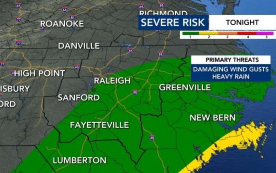
Storms will move into North Carolina on Monday night, bringing the possibility of heavy downpours, damaging wind gusts and hail.
WRAL meteorologist Mike Maze said there will be a 50% chance for rain at 7 p.m. The chance for rain will rise to 70% by 11 p.m.
Raleigh to the southeast are under a Level 1 risk for severe weather starting at 10 p.m. Thunder, lightning, heavy downpours and strong winds are possible.
Most of central North Carolina is also under a Flood Advisory until 2:30 a.m. Heavy downpours overnight could cause urban and small-stream flooding, especially in low-lying and poor drainage areas.
The Flood Advisory from the National Weather Service said locations that will experience flooding include Raleigh, Durham, Cary, Rocky Mount, Chapel Hill, Goldsboro, Roanoke Rapids, Henderson, Tarboro and Smithfield.
WRAL meteorologist Mike Maze said winds could gust up to 50 mph by 1 a.m. on Tuesday.
“If you hear the wind howling tonight … we’ve had a lot of rain, roots could be loosened [and] push trees around,” said Maze, adding that it could cause spotty power outages.
As of midnight, Duke Energy had reported 2,000 power outages in Wake County.
There is a chance for scattered showers Tuesday morning, with conditions becoming drier by lunchtime.
Temperatures on Tuesday will be some of the warmest of the week, with a high around 60 degrees.
Wind will pick up again on Tuesday afternoon, according to Maze.
“We could see gusts up to 25, maybe 30 mph,” he said.

The sun could make an appearance for the first time in days Tuesday afternoon and again on Wednesday, though its stay will be brief.
“The hard part of the forecast tomorrow is: How much sunshine will we see?” explained Maze. “This would be the first significant sunshine we’ve seen since last Tuesday.”

Overnight Wednesday, more rain is possible, and rain will fall Thursday midday through the evening. Highs in the upper 40s to low 50s.
There is a chance for freezing rain across the viewing area early Thursday morning if temperatures drop below 32 degrees. Person County and other areas north of the Triangle could see light glaze of ice, but it’s too early in the week to know the extent of those impacts.
By Friday, much of central North Carolina could see between 1.2 and 2 inches of rain.
“River flooding will be the end result of all this rain,” added Maze.
