- McDowell County wildfire spreads to 500 acres, evacuation orders in place
- Evacuations in Caldwell County due to wildfire
- Northwest Houston 'ghost neighborhood' caused by repeated flooding to become latest detention basin
- NHL playoffs: Hurricanes open playoffs Easter Sunday afternoon vs. Devils
- 2 wildfires spreading in rugged terrain in western North Carolina
Hail, damaging winds forecast for the San Antonio area on Wednesday
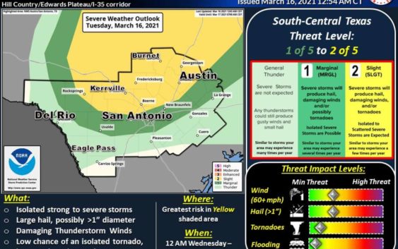

San Antonio could see severe weather on Wednesday including damaging winds and hail, forecasters say.
National Weather Service
Severe weather is on the way this week. Forecasters say the San Antonio area could see severe weather tonight through the early morning.
According to the National Weather Service, there is a risk for severe thunderstorms, though for a majority of the San Antonio area, the risk is marginal. The greatest threat for severe weather will be north of San Antonio including the Boerne area, NWS says.
Forecasters say the main threats will be large hail possibly less than 1 inch in diameter, damaging winds up to 60 mph, and a low risk of an isolated tornado.
READ ALSO: Veteran news anchor Randy Beamer did the weather. Here’s how he did.
Meteorologists say winds could cause large signs, trees, and utility poles to be blown down. As with any weather event, scattered power outages possible which means to make sure phones are charged and flashlights are handy.
Storms are expected between midnight and 7 a.m.
Candice.Garcia@express-news.net | Twitter @_candicegarcia