- National memorial to honor NC firefighter who died on duty during Hurricane Helene
- Gov. Josh Stein extends State of Emergency for western NC wildfires
- Gov. Stein extends state of emergency for NC wildfire threat
- Governor Stein extends state of emergency for NC wildfire threat
- Governor Stein extends emergency in 34 NC counties amid wildfire threat
Maze: Tornadoes, hail and flooding all possible Thursday
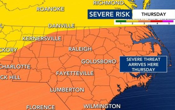
It’s not often that the National Weather Service’s Storm Prediction Center issues a level 3 alert for severe weather in central North Carolina, and this week’s warning is worth our attention, WRAL meteorologist Mike Maze said.
The Storm Prediction Center is warning about the chance for hail at least 2 inches in diameter, locally damaging winds up to 75 mph and even several tornadoes, which could blow at more than 100 mph on Thursday. The chance of greatest threat is between 2 and 8 p.m., Maze said.
Wednesday will warm with a high near 63 and just a 20% chance for showers, so nothing big to focus on there, but Thursday is when we expect things to change.
Then the severe threat sets in for Thursday. Thursday will also be the warmest day of the week, with a high over 70 degrees.
The day will begin with cloudy skies, a light breezy and a small chance for showers, then showers and storms becoming more likely later in the afternoon and into the evening.
“We have a high risk for damaging winds and tornadoes,” Maze said. “Be sure to have a reliable way to get instant weather information.”

Maze says there are a lot of possibilities as to what we could see happen on Thursday, but the timeline in which we could see severe weather appears clear.
“Numerous severe storms, more persistent and more widespread,” Maze said. “I’ve just looked at some new model data over the last half hour and I think the 2 p.m. to 8 p.m. timeframe of when this could impact us is still holding up.”

Maze says tornadoes and golf-ball-sized hail are possible in some places, but a lot of us will receive mostly heavy winds and rain, with potential flooding.

There is a 30 percent chance for rain on Friday, and highs will stay around 60 degrees. The weekend looks mostly sunny and dry but colder, with highs in the mid to upper 50s for both Saturday and Sunday.