- Hurricane inflation: The costliest storms in today's dollars
- Francine weakens moving inland from Gulf Coast after hurricane winds cause blackouts
- Tens of thousands in the dark as Hurricane Francine strikes Louisiana with 100 mph winds
- Hurricane Francine makes landfall in Louisiana as a Category 2 storm
- Lenovo signage installation begins at Hurricanes arena
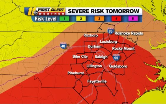
NC weather: 'Moderate' tornado chance, 'high' wind damage probability for Thursday
RALEIGH, N.C. (WTVD) — A warmer and relatively clear Wednesday will give way to a potentially dangerous Thursday.
To get the latest weather alerts sent straight to your phone, download the ABC11 app
Severe weather moving through the Deep South on Wednesday is expected to arrive in central North Carolina on Thursday afternoon.
New weather models caused the National Weather Service to increase our risk for severe weather from enhanced to moderate. This is a rare risk level.
The last time central North Carolina was in a moderate severe weather risk the day before storms arrived was late December 2012. Although, truth be told, that severe risk fizzled. The storms that arrived did not cause any reports of serious damage.
The latest update from @NWSSPC puts almost our entire viewing area under a Cat 4 (moderate) of 5 risk for severe storms on Thursday. Biggest threat=damaging winds. Almost 11 million people in this area. #ncwx pic.twitter.com/aFZplWTulm
— 𝘿𝙤𝙣 𝙎𝙘𝙝𝙬𝙚𝙣𝙣𝙚𝙠𝙚𝙧 (@BigweatherABC11) March 17, 2021
The exact timing of the storms remains in flux, but the First Alert Team said the latest information suggests the bulk of the storms will arrive mid afternoon and be gone by the early evening.
The damaging wind probability is at the highest risk level possible. There is a nearly 45 percent chance that damaging straight line wind will happen somewhere in central North Carolina. That means wind gust anywhere from 70-90 miles per hour.
The tornado threat is less likely but still possible. The threat level is moderate, which translates to a 15 percent chance that an EF2-EF5 tornado could happen.
Localized flooding and hail are also possible with the system.
WATCH: Big Weather breaks down most likely scenarios for Thursday’s storm
One thing to keep an eye out for happens Thursday morning. That’s when we could see some scattered showers ahead of the arrival of the severe storms.
The presence of Thursday morning showers would be a good sign, according to ABC11 Meteorologist Don “Big Weather” Schwenneker. He said showers in the morning would help stabilize the atmosphere, which in turn could reduce the severity of the storms when they arrive later in the day.
Once this weather event is over, rain could linger around into Friday. Temperatures during the day fall into the 40s with gusty wind.
Saturday and Sunday will see temperatures in the 50s, with more sun Saturday and more warmth Sunday.
If you’re a fan of the warmer spring weather, 70s will return next week.
GMA’s Ginger Zee joins the First Alert Team for Severe Weather townhall
Copyright © 2021 WTVD-TV. All Rights Reserved.