- Seven months after Hurricane Helene, Chimney Rock rebuilds with resilience
- Wildfire in New Jersey Pine Barrens expected to grow before it’s contained, officials say
- Storm damage forces recovery efforts in Lancaster, Chester counties
- Evacuation orders lifted as fast-moving New Jersey wildfire burns
- Heartbreak for NC resident as wildfire reduces lifetime home to ashes
WEATHER TIMELINE: Severe weather risk downgraded but dangerous storms still likely

Much of central North Carolina’s risk for severe weather has been downgraded, but severe weather is still likely throughout the region Thursday.
The National Weather Service has removed the category 4 risk for the area. Now the region is under a level 3 threat. The severe threat will last through 8 or 9 p.m., Chief Meteorologist Chris Hohmann said Thursday afternoon.
“Just because you see it’s downgraded you go, ‘Oh well that’s good.’ It is good; it means less of a chance, but it still means there is a pretty good chance of seeing severe weather really throughout the region today…just know that the risk for damaging winds really hasn’t decreased that much,” ABC11 Meteorologist Don “Big Weather” Schwenneker said.
Other counties under the tornado watch include Alamance, Chatham; Franklin, Granville, Halifax, Harnett, Hoke, Johnston, Lee, Moore, Nash, Orange, Person, Vance and Warren.
A line of storms is moving towards Greensboro and Charlotte. The line will push into central North Carolina later this afternoon and evening. We’re also watching out for any isolated storms that pop up ahead of the main line. pic.twitter.com/W9dRFidCwd
— Brittany Bell (@BrittanyABC11) March 18, 2021
Hohmann said all threats, including tornado, wind, and hail (to a lesser degree) remain, even though we are not in the “moderate risk” anymore.
Meanwhile, Gov. Roy Cooper signed a State of Emergency on Thursday afternoon in advance of expected severe weather across the state.
“This state of emergency will allow movement of trucks and equipment to respond to emergencies, rapidly restore power outages and clear debris after the storm passes,” Cooper said.
LIVE RADAR: storms headed to North Carolina
Timeline
From 12 p.m. to 4 p.m. in the Triangle, small but powerful cells could pop up around the region. These cells are the ones that have the highest chance of spinning up a tornado.
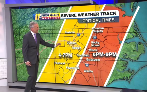
This critical timing happens between 3 p.m. and 7 p.m. for the easternmost counties of the region.
Timing for the Triangle is probably around 6 p.m. or so, Hohmann said, and the storms should be out of the ABC11 viewing area by 10 p.m. at the latest.
The main line of the storms moves through the region between 4 p.m. and 7 p.m. This batch of storms will bring the brunt of the damaging straight-line winds.
Potential Dangers
Damaging wind remains the main threat with this set of storms. There is around a 30 percent chance that damaging straight-line winds will happen somewhere in central North Carolina.
That means if you pick any area in the region, there is a 30 percent chance you’d see wind damage within 25 miles of that area.
WATCH: Wind, tornadoes, hail? Breakdown of what to expect in today’s storms
The tornado threat is less likely but still possible. The threat level is moderate, which translates to about a 10 percent chance that an EF2-EF5 tornado could happen.
“Even though there is less of a chance for a tornado, if we do see a tornado, there is potential that it could be a rather strong one,” Big Weather said.
Localized flooding and hail are also possible with the system.
Most of the area is now under an enhanced risk, level 3 out of 5. Hail, tornadoes, and damaging winds are still possible. The second image shows the timing. pic.twitter.com/qvGXa0mrd6
— Brittany Bell (@BrittanyABC11) March 18, 2021
This same system is the one that has spawned an estimated 25 tornadoes from Oklahoma to Alabama. Fortunately, at this time there are no reported deaths from the storm.
Once this weather event is over, rain could linger around into Friday. It will be breezy and colder with temperatures in the 40s. A chance for a rain/snow mix exists near the Virginia border late morning but no accumulation is expected.
Saturday and Sunday will see temperatures in the 50s, with more sun Saturday and more warmth Sunday.
School closings
Chatham, Durham, Franklin, Harnett, Hoke, Orange, Johnston, Granville, Cumberland, Person, Wayne and Wilson County and Chapel Hill-Carrboro City Schools will all be in remote instruction Thursday due to the impending weather.
On Thursday, Moore County Schools will release students three hours early and all after-school activities will be canceled.
Edgecombe County Schools will close two hours early.
Nash County Schools will close at 12:45 p.m. and 2 p.m.
Wake County Schools will have no live instruction. The schools will have an asynchronous learning day where teachers communicate assignments to students to complete on their own.
Meanwhile, anyone in Wake County who was scheduled to get the COVID-19 vaccine Thursday has had their appointment rescheduled for Friday. People who had Friday appointments will still have those appointments.
All COVID-19 testing sites in Wake County are also closed Thursday.
Copyright © 2021 WTVD-TV. All Rights Reserved.