- Fake job seekers are flooding the market, thanks to AI
- One set of evacuation orders lifted in Caldwell County after wildfire contained
- 'We gutted every building' | Chimney Rock rebuilding after Hurricane Helene
- 'We gutted every building' | Chimney Rock rebuilding after Hurricane Helene
- Debris from Hurricane Helene provides fuel, complicates containment for spring wildfires
Heavy rain, damaging winds possible across Charlotte area Friday

Brad Panovich is tracking a storm system that could bring heavy rain and damaging winds to the Charlotte, North Carolina area Friday.
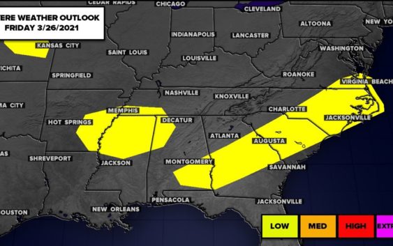
CHARLOTTE, N.C. — The First Warn Storm Team is tracking a storm system that could bring rain and thunderstorms to the Charlotte, North Carolina, region Friday and another outbreak of severe weather in parts of Mississippi, Alabama, Tennessee and Georgia Thursday.
Chief meteorologist Brad Panovich said Charlotte’s overall threat for severe weather is low, but some areas south and east of I-85 could get thunderstorms. Charlotte’s risk of severe weather remains low because the system will move through the area early Friday before the heating of the day produces thunderstorm fuel.
“The good news for the western Carolinas is we’re going to be in that sweet spot where the cold front is behind and coming in during the cool part of the morning,” Panovich said. “The overall risk is low. This is much lower than any point last week.”
Panovich said the biggest risk from Friday’s storms would likely be straight-line winds. The risk of tornadoes and hail are much lower for the Carolinas than last week.
A band of strong thunderstorms will move into the North Carolina mountains Thursday night. Panovich said these storms will bring a low risk of severe weather to areas like Boone, Asheville and Hendersonville.
“It should be falling apart but sometimes these storms have enough momentum to keep the gusting winds coming out of them, so that potentially could be moving in,” Panovich said.
By early Friday morning, between 2 a.m. and 5 a.m., the storms will begin to weaken as they move through the Charlotte area. The timing works out well for reducing our severe weather threat, plus Panovich says the majority of the energy in the system is above the Great Lakes and Midwest.
“I would definitely be a little more weather aware than normal,” Panovich said. “But on a scale of 1 to 5, we’re probably closer to a 1 for tornadoes, as opposed to like a 3 last week.”