- Fake job seekers are flooding the market, thanks to AI
- One set of evacuation orders lifted in Caldwell County after wildfire contained
- 'We gutted every building' | Chimney Rock rebuilding after Hurricane Helene
- 'We gutted every building' | Chimney Rock rebuilding after Hurricane Helene
- Debris from Hurricane Helene provides fuel, complicates containment for spring wildfires
Tornado Warning for Stanly County
A line of severe thunderstorms is approaching Charlotte and moving eastward across the Carolinas.
CHARLOTTE, N.C. — The National Weather Service has issued a tornado warning for Stanly County in North Carolina until 7 p.m.
Portions of Union and Cabarrus counties in the most recent warning have been allowed to expire.
At 6:15 p.m., a severe thunderstorm capable of producing a tornado was located over Midland and moving east at 35 mph.
Locations inside this warning include, but are not limited to, Albemarle, Norwood, Stanfield, Locust, Morrow Mountain State Park, and Okaboro.
The tornado warning was issued quickly as the thunderstorm suddenly began rotating, explained WCNC Charlotte First Warn Storm Team Chief Meteorologist Brad Panovich. The quick-forming rotation is a key factor of the QLSC threat impacting the Carolinas Thursday.
While the entire line of storms is not considered severe, it is advised everyone stays weather-aware and continues to monitor for quick-forming severe weather.
QLCS, which stands for a quasi-linear convective system, is the meteorological term for a squall line. On radar, the system would be recognized as a line of thunderstorms moving more-or-less at the same speed and same direction.
The following video, recorded at 4:40 p.m. during Thursday’s severe weather coverage, explains the severe weather threat from a QLCS line of thunderstorms.
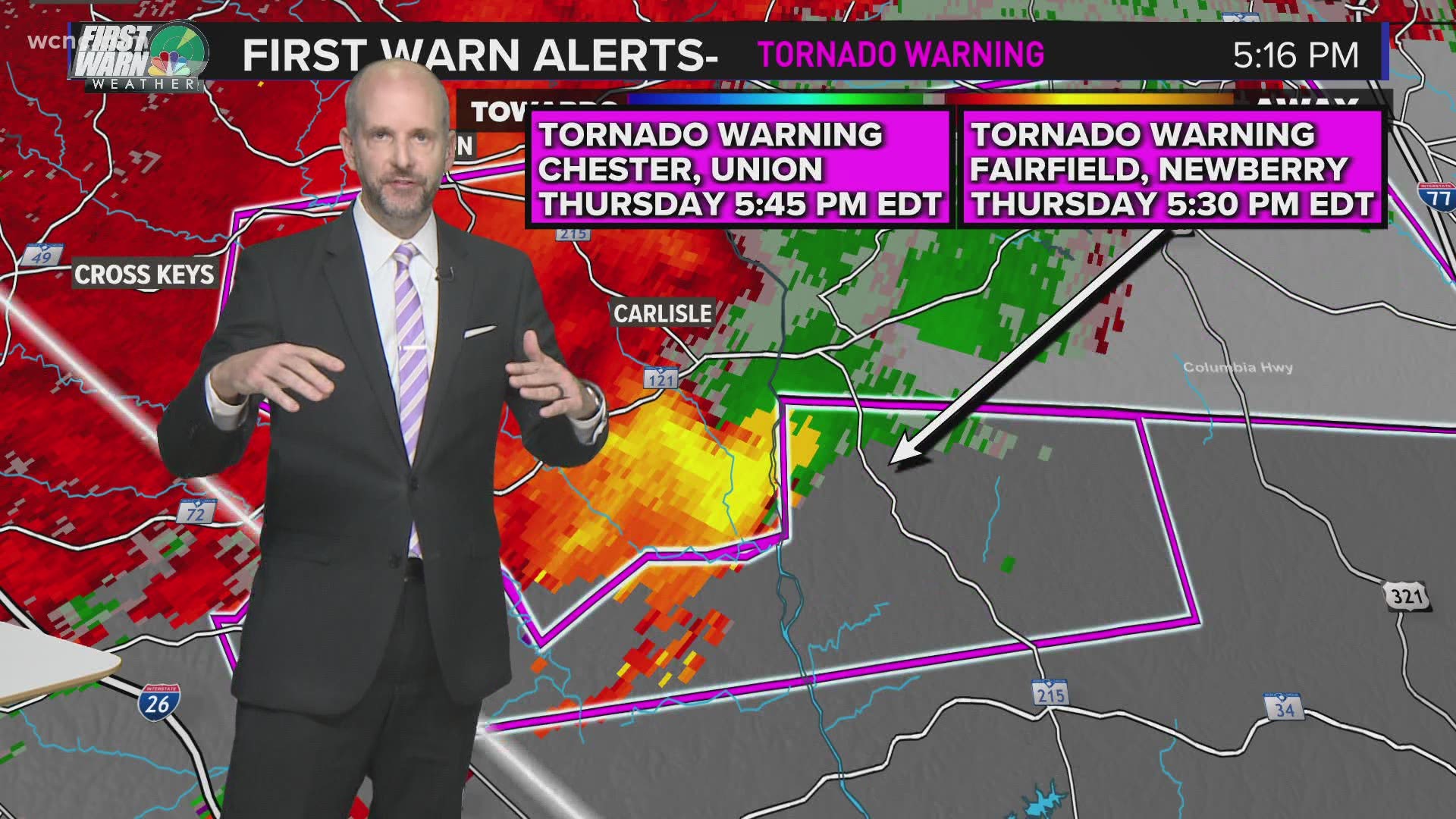
As the severe line of thunderstorms moved eastward across the Carolinas, it prompted the National Weather Service to issue several previous tornado warnings. Earlier Thursday, tornado warnings had been issued for counties including Chester, Laurens, Union (South Carolina), and Fairfield in South Carolina. As that severe thunderstorm capable of producing a tornado moved eastward earlier Thursday, it caused damage across several counties:
- Trees fell near Hickory Taven in Laurens County, South Carolina.
- More trees were toppled along Highway 72 in the Whitmire area of Newberry County, South Carolina.
- In Union County, South Carolina, one-inch size hail was reported. Numerous trees and powerlines were also down.
- In Fairfield County, South Carolina, one-inch size hail also fell along Old Douglas Road. Trees were also down along Ashford Road near Winnsboro.
- More damage reports were expected to be reported later Thursday.
The following video, recorded around 5 p.m. Thursday during severe weather coverage, explains the threat from hail.

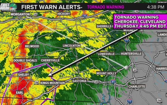
A previous tornado warning for Cleveland County, NC has been allowed to expire.
If you find yourself inside a tornado warning, you should:
- Head into a sturdy structure. Find a location inside the structure that is on the lowest possible level of the structure and the most interior location. You want to put as many walls between you and the outside as possible.
- Stay away from windows.
- If time allows, make sure you’re wearing the following as you head into shelter: Shoes, helmet, pants, and any other protective gear.
- A way to watch or listen to severe weather coverage to know the latest weather threat
Real-time radar:
The possible-tornadic rotations seen Thursday in the Carolinas are caused by rotation inside these strong-to-severe thunderstorms.
The following video, recorded at 5:15 p.m. during Thursday’s severe weather coverage, explains how rotation is detected on radar inside severe thunderstorms capable of producing tornadoes:
While some scattered strong-to-severe storms are possible in the Carolinas, the nation’s biggest and most extreme risk is again over Mississippi, Alabama, Georgia, and Tennessee — just a week after the Mid-South region also faced the same risk.
Chief Meteorologist Brad Panovich said Charlotte’s overall threat for severe weather is low, but some areas south and east of I-85 could get thunderstorms. Charlotte’s risk of severe weather remains low because the system will move through the area early Friday before the heating of the day produces thunderstorm fuel.
Panovich said the North Carolina mountains could be at risk for flash flooding and damaging winds as the first batch of storms moves in Thursday evening. Areas on the eastern-facing slopes are at the highest risk of localized flooding.
“The overall threat is low, but I actually think the biggest risk, believe it or not, for severe weather might be in the mountains around 8 or 9 o’clock as those storms that form earlier in the day make a run at us,” Panovich said.
The good news is the threat for severe weather for most of the Charlotte region is much lower than last week, when strong storms rocked the region with multiple tornado warnings. Damaging winds will be the primary threat in Charlotte, with some flash flooding possible in the mountains. The hail and tornado risk is minimal, but not non-existent.
“It’s one of those events where the threat is not huge but it’s also not zero,” Panovich said. “We’ve got to keep a close eye on that potential tonight because I do think some of these storms, one or two might become severe this evening into the overnight.”
By early Friday morning, between 2 a.m. and 5 a.m., the storms will begin to weaken as they move through the Charlotte area. The timing works out well for reducing our severe weather threat, plus Panovich says the majority of the energy in the system is above the Great Lakes and Midwest.
“I would definitely be a little more weather-aware than normal,” Panovich said. “But on a scale of 1 to 5, we’re probably closer to a 1 for tornadoes, as opposed to like a 3 last week.”
Panovich recommends everyone have two ways to receive severe weather alerts, including the WCNC Charlotte app, which will send alerts to users based on their location.