- Seven months after Hurricane Helene, Chimney Rock rebuilds with resilience
- Wildfire in New Jersey Pine Barrens expected to grow before it’s contained, officials say
- Storm damage forces recovery efforts in Lancaster, Chester counties
- Evacuation orders lifted as fast-moving New Jersey wildfire burns
- Heartbreak for NC resident as wildfire reduces lifetime home to ashes
Flooding concerns across Charlotte metro after heavy rain
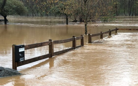
The South Fork River in Gaston County, North Carolina, is expected to rise above 14 feet after heavy rain fell in the area Thursday and Friday.
GASTON COUNTY, N.C. — Now that heavy rain and thunderstorms have moved out of the Charlotte area, flooding will be a concern for low-lying areas along rivers, creeks, and streams across the region.
In Cramerton, North Carolina, the South Fork River began flooding its banks early Friday morning with officials shutting down the Centennial Center Pier due to the rising levels.
First Warn Meteorologist Chris Mulcahy showed the latest forecast had the river rising another two feet from its previous forecast of 12.2 feet. Moderate flood levels begin at 13 feet, according to Mulcahy.
Should the South Fork crest at 14 feet, that would be the 11th-highest in recorded history.
The river isn’t expected to reach its full crest until around 4 p.m. Friday.
In Cabarrus County, the Rocky River is expected to crest at 14.5 feet near Irish Buffalo Creek. That would be the highest crest since January of 2013, according to National Weather Service records.
The Broad River, near the North Carolina-South Carolina border town of Boiling Springs, is also expected to see moderate flooding Friday. According to the National Weather Service, the Broad River is forecast to crest at 16.4 feet. The river’s level was observed at 15.3 feet Friday morning.