- Fake job seekers are flooding the market, thanks to AI
- One set of evacuation orders lifted in Caldwell County after wildfire contained
- 'We gutted every building' | Chimney Rock rebuilding after Hurricane Helene
- 'We gutted every building' | Chimney Rock rebuilding after Hurricane Helene
- Debris from Hurricane Helene provides fuel, complicates containment for spring wildfires
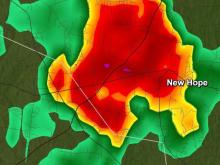
Tornado Warning issued for Wake, Johnston, Wilson counties
Raleigh, N.C. — Get prepared for a stormy weekend.
A Tornado Warning has been issued for Wake, Johnston, Wilson and Nash counties until 6 p.m. All weather alerts can be found here.
Hail is also reported to be falling in Raleigh.
The main threat is damaging wind gusts, which could reach up to 60 mph. Pea-sized hail has been seen falling in High Point and Durham, and could begin falling in Raleigh as the storms move through. The heavy rain is causing “white out conditions,” so be cautious if driving.
The severe weather risk has been raised to Level 2 for much of central NC.
Greensboro currently has around 1,000 people without power, and Charlotte has around 4,000 without power. The Triangle has reported around 100 people without power. WRAL will be prepared to provide updates if more outages are reported.
A large, dark shelf cloud moved across downtown Raleigh, as heavy storms moved through.
The Tornado Warning issued for Lee and Moore counties was allowed to expire at 5 p.m.

Track rain with the DualDoppler5000.
People impacted by the passing storms shared photos of hail that fell in multiple counties around cental NC. A sizable amount of hail was shown on a highway near Greensboro.

A video showed hail falling in North Raleigh as well.
Other than the severe weather threat and rainy forecast, Saturday will be warm and overcast with a high in the 70s.

The weather shouldn’t be anything like what Alabama and Georgia witnessed Thursday, when a series of tornadoes killed at least five people.
Sunday outlook

There is another high chance for rain on Sunday and a Level 2 risk for severe weather in the afternoon and evening. Temperatures will be in the 70s, but the humidity won’t be as high.
“It’s going to be windy at times,” Sheerwood said. “A few showers will be possible in the morning on Sunday, but we’re really watching the cold front off to the west for the afternoon.”
Sherwood says you need to be inside by the afternoon on Sunday as showers and storms develop. Damaging winds, isolated tornadoes and small hail will be possible. However, we won’t see much directional shear, which should keep the tornado risk low.

By Monday, temperatures will be slightly cooler, in the mid 60s.
The warmth over the next four days will be comparable to normal temperatures in the region for the end of May.
It may appear that springtime warmth is here to stay, but WRAL meteorologists recommend waiting to plant delicate flowers and other seasonal additions to gardens. The average final spring freeze usually occurs between April 1 and April 10 in the Triangle. The average date of the last hard freeze is anywhere from March 21 to March 31.
With springtime comes an increase in pollen and allergies, and the chances of feeling that impact across the region will increase as the week goes on.