- Hays County emergency alerts cause confusion during Tuesday's wildfires
- Tuesday's wildfires scorched more than 500 acres in south Bexar County
- How big were this week's wildfires in Bexar County?
- Crews contain wildfire in southeast Williamson County
- Wildfire contained to 300 acres in northwest Matagorda County
Most of North Carolina under Level 2 severe weather risk on Sunday with wind, hail and isolated tornado possible
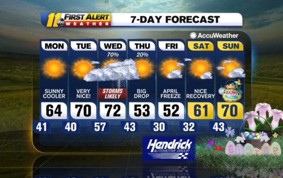
RALEIGH, N.C. (WTVD) — Showers and storms will once again be present this afternoon and evening and some of those storms will be strong, even reaching severe limits.
We are in level 2 out of 5 risk of severe weather today. Damaging wind gusts, hail and brief downpours will be the main threats; however, there is a chance for a few isolated tornadoes as well. Meanwhile, there is a level 3/5 risk of severe weather for areas along the Virginia line. That is where the tornado risk is greatest.
The first round of showers and storms arrives this afternoon but a strong line will develop ahead of a cold front late this afternoon/early this evening.
As this front shifts to the east tonight, drier and cooler air will settle in overnight. A cooler trend is expected with a clearing sky as dry air from the northwest sweeps into the region. Low temperatures tonight will drop down into the lower and middle 40s, snapping the mild pattern that has persisted for the last few days. High pressure is expected to strengthen over the Southeast to start the week, keeping the area dry through Tuesday.
A second cold front will move east on Wednesday. Rain and thunderstorms can once again be strong during this event, with downpours and locally damaging winds possible.
A noticeably cooler trend will usher in late this week following the passage of this cold front. High temperatures will be limited to the 50s for most, some 10-15 degrees below normal for early April standards. Warmer air will make a return to the region this weekend once high pressure traverses over the Southeast coast.
Stay Weather Aware Tonight,
Robert Johnson
Copyright © 2021 WTVD-TV. All Rights Reserved.