- National memorial to honor NC firefighter who died on duty during Hurricane Helene
- Gov. Josh Stein extends State of Emergency for western NC wildfires
- Governor Stein extends state of emergency for NC wildfire threat
- Governor Stein extends emergency in 34 NC counties amid wildfire threat
- Texans can buy emergency preparation supplies tax-free April 26-28 ahead of severe weather season
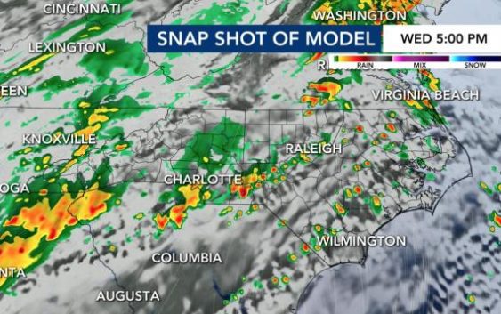
Level 1 threat for severe storms Wednesday, damaging winds and hail possible
Our gorgeous weather today turns sour as the next cold front moves through the area Wednesday night.
“It appears March could go out like a Lion with a Level 1 risk for severe storms,” meteorologist Mike Maze said.
Maze says that as of now, it appears the timeline for severe would be from 3 p.m. through 9 p.m. Wednesday.
“The main threats are damaging wind gusts and hail and then perhaps an isolated tornado,” he said. “The chance for a tornado to spin up is small. The risk we face tomorrow is less than what we saw Saturday and Sunday.
Rain chances will be pretty high Wednesday with a 70% chance for showers and storms in the afternoon and evening, with showers and some storms lasting overnight Wednesday into Thursday morning.

There’s about 50% chance for rain into the morning commute on Thursday.
“I am not anticipating any severe weather overnight Wednesday and into Thursday morning since the storm energy is dramatically reduced after midnight,” Maze said.

Maze says the rain should leave our area by early afternoon Thursday.
Friday and into the Easter Holiday Weekend look cold initially with freezing lows Friday and Saturday morning and highs Thursday and Friday in the 50s. Easter Sunday is dry with a high around 70!
At least the weekend looks clear and sunny, with highs in the low 60s for Saturday and the low 70s for Easter Sunday.
There are ways to protect your plants for Tuesday’s frost and Friday’s potential freeze. Be sure to water plants in the afternoon, cover plants at night and then remove the cover in the morning.
