- Severe weather threat this weekend
- The Pick of the Week today; severe weather chances by the end of the weekend
- Chimney Rock business rebuilds with state support after hurricane
- One year after devastating Panhandle wildfires, Canadian resident reflects on the work of rebuilding
- Hays County judge says software glitch caused some communication issues during wildfires
Sunny, warm start to Friday, but severe weather is possible this evening
RALEIGH, N.C. (WTVD) — Part of central North Carolina has been upgraded to a level 2 risk for severe weather.
A Severe Thunderstorn Warning was issued for Hoke and Moore counties on Friday afternoon. until 4:45 p.m. Granville and Person counties were also under a Severe Thunderstorm Warning until 5 p.m.
The National Weather Service said that at 4 p.m. a severe thunderstorm was located over Hoffman, about 12 miles southwest of Southern Pines and moving northeasterly at 30 mph.
Click here for First Alert Doppler XP
The storm could bring 60 mph wind gusts and half-dollar-sized hail. Winds could damage roofs, siding and trees, the NWS said. People should move indoors and stay away from windows.
The region was under a level 1 risk starting Friday morning, but the National Weather Service increased that risk for northern parts of the region.
Click here to view the latest weather advisories.
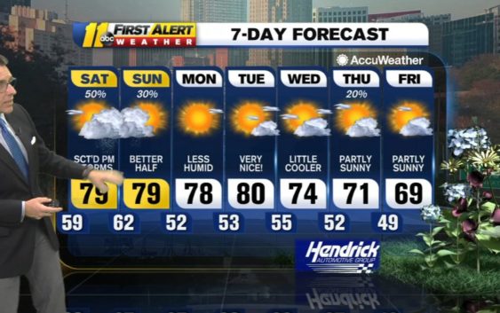
Most of the day was sunny and warm, but there is a chance that more strong storms will pop up in the evening, especially near the Virginia border and down to RDU.
SPC has upgraded us to Level 2 out of 5 risk for severe weather today. Timing likely through the evening hours. Main threat will be damaging winds and hail, but an isolated tornado can’t be ruled out. pic.twitter.com/l8kRXi9FkQ
— Steve Stewart (@StewartABC11) April 9, 2021
Some of the storms could have damaging winds but the severe threat should end by 11 or midnight. Lows will be in the mid-50s to 60.
Get weather on the ABC11 News app.
Rain will not wash out the entire ABC11 viewing area. Instead, certain spots could see quick but strong storms consisting of frequent lightning, gusty wind and heavy downpours.
So, if you have outside plans Friday evening, you may want to have a backup option. It’s probably not necessary to go ahead and change those plans, but having a backup in case storms do develop would serve you well.
This chance for rain comes after more than a week of dry weather. The last measurable rainfall at RDU happened March 31.
Click here for the latest weather forecast.
Saturday brings with it another chance for storms. Again with the higher chance of rain coming in the afternoon and evening. Otherwise, it will be partly sunny with highs ranging from 75-81.
Some weather models show rain Sunday too, and showers or even a storm are possible along I-95 in the afternoon. Again, highs will be from 75-81.
Copyright © 2021 WTVD-TV. All Rights Reserved.