- David & Nicole Tepper increase Hurricane Helene relief commitment to $750k
- David & Nicole Tepper increase Hurricane Helene relief commitment to $750k
- McDowell County wildfire spreads to 500 acres, evacuation orders in place
- Evacuations in Caldwell County due to wildfire
- Northwest Houston 'ghost neighborhood' caused by repeated flooding to become latest detention basin
Large hail, damaging winds in the forecast for the San Antonio area
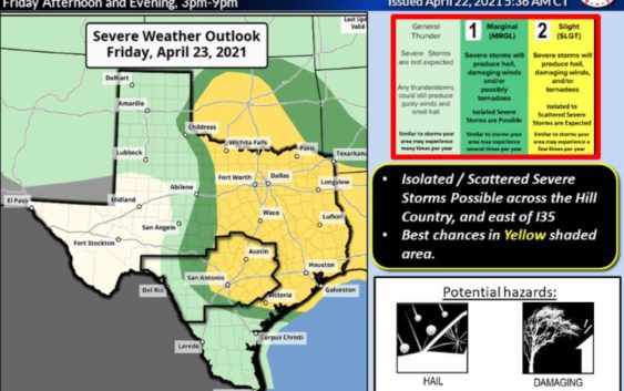

San Antonio area has a slight risk for severe weather, according to forecasters.
National Weather ServiceExpect a dreary start to the day on Friday followed by severe storms in the area.
According to National Weather Service, San Antonio could see pockets of severe weather Friday afternoon.
“The window for severe storms is looking to be between 1 p.m. and 7 p.m.,” said meteorologist Aaron Treadway.
READ ALSO: San Antonio entering Stage 2 water rules this week due to low rainfall
Large hail and damaging winds will be the main threat with these storms. Treadway says the storms should be out of the area by 10 p.m.
Maps from the National Weather Service show much of Texas is under some threat for severe weather.
Unfortunately, Treadway says the rain won’t be enough to pull us out of the Texas drought we are in.
San Antonio is currently under Stage 2 water restrictions.
Read more from Candice