- Temporary bridges in Avery County at risk due to severe weather threat
- FEMA extends aid as Hurricane Helene recovery efforts surpass $360M
- Nearly every North Carolina wildfire caused by people, researchers say
- Weather IQ: How do wildfires ignite?
- EPA faces backlash for debris site near Los Angeles communities after massive wildfires
NC Weather: Severe weather risk increased to level 2 for central North Carolina
RALEIGH, N.C. (WTVD) — This week starts with a chance for severe weather across central North Carolina.
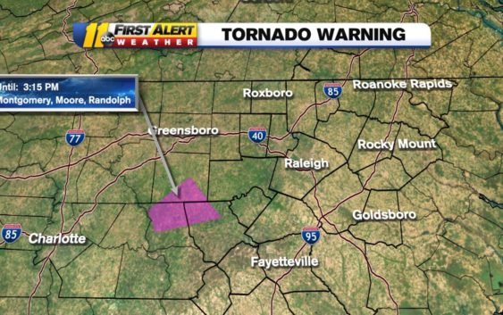
TORNADO WARNING: Moore County
TORNADO WATCH: Scotland County
To get the latest weather alerts sent straight to your phone, download the ABC11 app
The National Weather Service has all of the region in a level two threat for severe storms. Monday morning, only the southernmost part of the region was under a level two risk, but the NWS has now extended that risk throughout the region.
There is a 60 percent chance of storms developing. If they do develop in your area, they could be severe with the highest threat being damaging wind. There’s a lower risk the storms could spawn an isolated tornado or hail.
Tornado watch vs warning: What to do when you see alert messages
The storms could continue until 8 p.m.
Click here for the latest weather forecast.
Temperatures Monday will reach into the 80s. Tuesday will be the hottest day of the week with temperatures peaking into the 90s.
Another chance for storms arrives Wednesday.
The Mother’s Day weekend is looking dry with temperatures in the 70s and 80s.
Copyright © 2021 WTVD-TV. All Rights Reserved.