- David & Nicole Tepper increase Hurricane Helene relief commitment to $750k
- David & Nicole Tepper increase Hurricane Helene relief commitment to $750k
- McDowell County wildfire spreads to 500 acres, evacuation orders in place
- Evacuations in Caldwell County due to wildfire
- Northwest Houston 'ghost neighborhood' caused by repeated flooding to become latest detention basin
Parts of central NC at risk for damaging winds, hail during Friday's Level 1 risk for severe weather
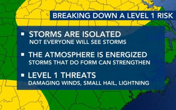
Raleigh, N.C. — Parts of the WRAL viewing area is under a Level 1 risk for severe weather on Friday.
“It’s quite possible we could see strong, to maybe severe storms,” said WRAL meteorologist Mike Maze.
From Raleigh down east to the coast is under the Level 1 risk for Thursday, with the biggest threats being damaging wind gusts and large hail.
“We’re talking quarter-size, maybe half-dollar size hail if the storms are strong enough to develop that,” said Maze.
Other parts of the WRAL viewing area could see thunderstorms, according to Maze.
A 50 percent chance for storms begins a 8 a.m. and continues through the afternoon.
“I think, in the afternoon our showers and storms may be more concentrated along and east of I-95,” said Maze.
Temperatures will remain cool and breezy throughout the day, with highs in the upper 60s. If there is more cloud cover, highs might only reach the mid 60s, according to Maze.

The good news is that the weekend is still looking pleasant, according to WRAL meteorologist Campbell.
Highs will be in the 70s on Saturday and will increase to the 80s on Sunday.
But, there is a chance for rain and storms overnight Sunday.
