- Austin adopts new map that greatly expands area at risk of wildfire
- CenterPoint Energy accelerates infrastructure improvements ahead of hurricane season
- Carolina Hurricanes playoff tickets go on sale Thursday
- Ask the Meteorologist: Why do tornadoes target Tornado Alley, Dixie Alley?
- Nonprofit closes distribution site that aided thousands after Hurricane Helene
Damaging winds, hail possible throughout day on Friday
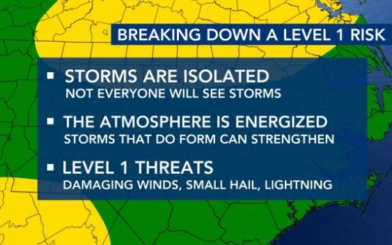
Raleigh, N.C. — Most of the WRAL viewing area is under a Level 1 risk for severe weather on Friday.
Around 4:30 a.m., a slow-moving band of showers and storms were approaching the western part of our area. Heavy rain and lightning are possible.
“We could certainly see some wind damage and possibly some hail with these systems” said WRAL meteorologist Elizabeth Gardner. “It’s likely to be pretty loud. There’s a lot of lightning with this.”
The biggest threats being damaging wind gusts and large hail. The threat will be with us on and off throughout the day as more bands of rain should move through during the afternoon.
“Thunderstorms could develop as early as the late morning hours,” said WRAL meteorologist Kat Campbell. “Storms will be possible until the evening and scattered in nature.”
“We’re talking quarter-size, maybe half-dollar size hail if the storms are strong enough to develop that,” said WRAL meteorologist Mike Maze.
Those not included in the Level 1 risk could still see thunderstorms, according to Maze.
“I think, in the afternoon our showers and storms may be more concentrated along and east of I-95,” said Maze.

Temperatures will remain cool and breezy throughout the day, with highs in the upper 60s. If there is more cloud cover, highs might only reach the mid 60s, according to Maze.
By sunset, it will quiet down and make for a nicer Friday night, said Campbell.

The good news is that the weekend is still looking pleasant, with comfortably cool mornings and pleasant afternoons.
Highs will be in the 70s on Saturday and will increase to the 80s on Sunday.
“A warm front passes early Sunday and the southwest wind behind the front will help ramp up temperatures again,” said Campbell.
But, there is a chance for rain and storms overnight Sunday.
