- Fake job seekers are flooding the market, thanks to AI
- One set of evacuation orders lifted in Caldwell County after wildfire contained
- 'We gutted every building' | Chimney Rock rebuilding after Hurricane Helene
- 'We gutted every building' | Chimney Rock rebuilding after Hurricane Helene
- Debris from Hurricane Helene provides fuel, complicates containment for spring wildfires
Tornado watch in effect until 9 p.m. for several counties

A Flash Flood Watch continues for all of the Houston area, and much of Texas, until Thursday morning. Here’s the latest from the KHOU 11 Weather Team.
HOUSTON — KHOU 11 Meteorologist Addison Green is closely monitoring more heavy rainfall on the way to Texas, including the Houston area.
We already saw isolated reports of street flooding on Monday, and with the grounds already so saturated, more flooding is likely on the way.
A tornado watch is in effect until 9 p.m. Tuesday for Montgomery, Walker, Grimes, Washington, Austin, Colorado, Waller and San Jacinto counties.
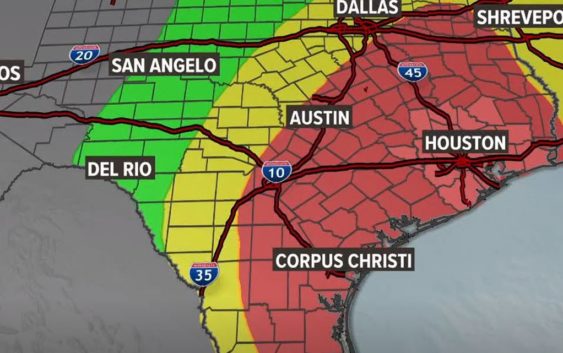
As of Tuesday, much of the state of Texas remains under a Flash Flood Watch. This includes the Dallas region down to Austin, San Antonio, Corpus Christi and Houston.
When Houston’s flood threat will be the greatest
TUESDAY: Mostly a marginal to slight flood risk across Houston. A moderate flood risk exists from Austin to Dallas and areas east and just northeast of Houston. Keep this in mind if you’re planning to take I-45 North or I-10 West/East out of town today. The rain chance increases today around lunchtime and then again after 8 p.m. into the overnight hours.
WEDNESDAY: Rain continues from overnight Tuesday and throughout the day. The forecast puts Southeast Texas, including the entire Houston area, under a moderate risk of heavy rainfall and a flood potential. “That’s our highest potential for flooding will be all throughout your Wednesday,” says Meteorologist Chita Craft.
THURSDAY: Texas will still see rain, but after the morning hours, it won’t be as heavy as previous days, thankfully. Dallas to Austin will have a marginal risk of flooding, and Houston and much of Southeast Texas will have a slight risk of flooding.
How much rain are we talking?
Currently, our greatest concern is street flooding, especially in areas that get the worst of Wednesday’s downpours. We are not expecting widespread flooding in homes or structures, but those who live in very low-lying areas or areas with draining issues will want to keep a close eye on the radar. Either way, the rain is going to make for a nasty commute Wednesday. Remember, turn around – don’t drown. If you can’t see the bottom of the roadway, don’t assume you know how deep the water is.
Chita Craft says, in total, some areas could get more than 6 inches of rain by the weekend, especially along the I-45 corridor and areas east. But she also warns this forecast is constantly changing.
“The problem is, the thunderstorms we’re expecting, you just don’t know exactly where they’re going to fire up and how long they’re going to linger,” says Craft. “There’s still a lot of uncertainty when it comes to Wednesday’s forecast, but it is expected to be a washout either way.”
The National Weather Service indicates some isolated areas could even get up to 10 inches of rain: