- After Hurricane Beryl, Texas lawmakers push for generators at senior living facilities
- 20-million-gallon detention basin in Meyerland designed to help prevent flooding
- Firefighters report significant progress on McDowell County wildfire
- How to watch the FireAid benefit concert for LA wildfire relief
- FireAid, a benefit for LA wildfire relief, is almost here. Here’s how to watch and donate
Tornado Warning in effect for parts of Harris, Chambers, Liberty counties until 11 p.m.
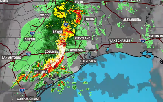
A Tornado Watch is also in effect for the Houston area until 2 a.m. Here’s the latest from the KHOU 11 Weather Team.
HOUSTON — The KHOU 11 weather team continues to monitor more heavy rainfall on the way to Texas, including the Houston area.
There were isolated reports of flooding Monday and with the grounds already so saturated, more flooding is likely on the way.
A Tornado Warning is in effect for southeastern Harris County, northwestern Chambers County and southwestern Liberty County until 11 p.m.
A Flash Flood Warning is in effect until 12:45 a.m. Wednesday for northern Brazoria County, Fort Bend County, western Galveston County, Harris County, southern Montgomery County, eastern Waller County, northeastern Wharton County and southeastern Austin County.
A Tornado Watch is in effect until 2 a.m. Wednesday for the Houston area.
A Flash Flood Watch is in effect for the following counties: Austin, Brazoria, Chambers, Galveston, Harris, Jackson, Matagorda, Colorado, Fort Bend, Grimes, Montgomery, Liberty, Polk, San Jacinto, Trinity, Walker, Waller, Washington and Wharton Counties.
As of Tuesday, much of the state of Texas remains under a Flash Flood Watch. This includes the Dallas region down to Austin, San Antonio, Corpus Christi and Houston.
What to do during a Tornado Warning
People within the affected area should seek shelter immediately and take action. The warning means there is an imminent danger to life and property. Here are some tips:
- Get In: Get inside a sturdy structure, find shelter in an interior room, away from windows.
- Get Low: Seek shelter on the lowest floor possible, or underground, if possible.
- Hold On: Grab on to a sturdy object and hold on.
When Houston’s flood threat will be the greatest
Today, the rain chance increases after 8 p.m. into the overnight hours. The good news is that it didn’t rain much. The bayous are all down to start what will be a wet and stormy night.
Tonight, we can expect one to three inches of rain with more than five inches in some spots.
WEDNESDAY: Two rounds of storms move through on Wednesday, according to the latest model runs. The first pushes through our eastern fringe counties by 2 a.m. and off into Louisiana by sunrise. Another round comes in late afternoon and may sit on us for a while which is a little concerning.
THURSDAY: Texas will still see rain, but after the morning hours, it won’t be as heavy as previous days, thankfully. Dallas to Austin will have a marginal risk of flooding, and Houston and much of Southeast Texas will have a slight risk of flooding.
How much rain are we talking?
Currently, our greatest concern is street flooding, especially in areas that get the worst of Wednesday’s downpours. We are not expecting widespread flooding in homes or structures, but those who live in very low-lying areas or areas with draining issues will want to keep a close eye on the radar. Either way, the rain is going to make for a nasty commute Wednesday. Remember, turn around – don’t drown. If you can’t see the bottom of the roadway, don’t assume you know how deep the water is.
Chita Craft says, in total, some areas could get more than 6 inches of rain by the weekend, especially along the I-45 corridor and areas east. But she also warns this forecast is constantly changing.
“The problem is, the thunderstorms we’re expecting, you just don’t know exactly where they’re going to fire up and how long they’re going to linger,” says Craft. “There’s still a lot of uncertainty when it comes to Wednesday’s forecast, but it is expected to be a washout either way.”
The National Weather Service indicates some isolated areas could even get up to 10 inches of rain: