- Austin adopts new map that greatly expands area at risk of wildfire
- CenterPoint Energy accelerates infrastructure improvements ahead of hurricane season
- Carolina Hurricanes playoff tickets go on sale Thursday
- Ask the Meteorologist: Why do tornadoes target Tornado Alley, Dixie Alley?
- Nonprofit closes distribution site that aided thousands after Hurricane Helene
Weather Timeline: Break from rain for now but Flash Flood Watch continues

If you need to get out today, your best bet is to do it before early afternoon. That’s when we could see another round of thunderstorms push through.
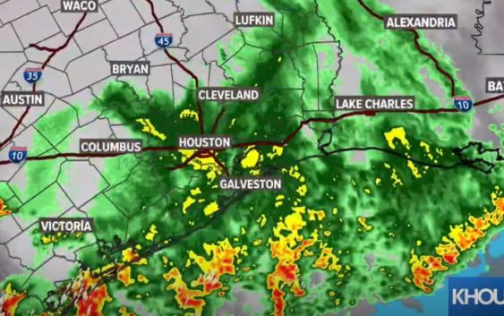
HOUSTON — We’re getting a brief break from the heavy rain after strong storms moved through southeast Texas Tuesday and early Wednesday bringing strong wind, heavy rain and plenty of lightning.
The entire area remains under a Flash Flood Watch through Thursday morning.
If you need to get out today, your best bet is to do it as early as possible. By early afternoon, we could see another round of thunderstorms push through, according to KHOU 11 Meteorologist Addison Green. The threat goes up from there.
TRAFFIC MAP: Look for reported incidents on your morning commute
WEATHER MAP: Track the rain & storms on our interactive radar map
Weather timeline
We’re just seeing light showers for southern Harris County until early afternoon. That turns to moderate rainfall with thunderstorms starting around noon for the entire county.
If you’re in Fort Bend, the heavier rainfall starts earlier around 11 a.m. and for those of you in Montgomery County, expect to see more rainfall between 1 p.m. and 2 p.m.
The storms will increase in intensity through the afternoon hours.
Right now, widespread flooding is not a threat, but there could be isolated pockets of heavy rain, so stay weather aware.
Active watches and warnings in our area:
The National Weather Service in League City has extended the Flash Flood Warning for Jackson County in south central Texas and West Central Matagorda County in southeastern Texas until 11:30 a.m. Wednesday. Doppler radar indicated thunderstorms produced heavy rain across the warned area. Between 3 and 5 inches of rain have fallen. Flash flooding is ongoing, and continuing light rain is prolonging the time needed for water to recede
A Flash Flood Watch is in effect for the following counties through Thursday morning: Austin, Brazoria, Chambers, Galveston, Harris, Jackson, Matagorda, Colorado, Fort Bend, Grimes, Montgomery, Liberty, Polk, San Jacinto, Trinity, Walker, Waller, Washington and Wharton Counties.
Earlier Severe Thunderstorm and Tornado Warnings have expired.
CURRENT WATCHES & WARNINGS: You can check all watches and warnings here
What’s next
KHOU 11 Chief Meteorologist David Paul said Tuesday night’s storms moved quickly, which helped to keep our bayous and streams within their banks. We will still have to watch today’s rain, however, as the showers are now more slow-moving, and the ground is very saturated.
Watch her latest update here:
We can expect to continue to get scattered showers throughout the day Wednesday and through Thursday morning before the rain chances let up a little. While it won’t be as bad, we will still have clouds and a chance of scattered showers and storms through the weekend. Unfortunately, we don’t have any really nice sunny days in the forecast anytime soon.
Power outages
CenterPoint Energy is reporting power outages across the Houston area. Click here to see the map. As of 8:35 a.m. Wednesday, there were over 17,000 customers without power.
Lightning caught on video
How much rain are we talking?
Currently, our greatest concern is street flooding, especially in areas that get the worst of Wednesday’s downpours. We are not expecting widespread flooding in homes or structures, but those who live in very low-lying areas or areas with draining issues will want to keep a close eye on the radar. Either way, the rain is going to make for a nasty commute Wednesday. Remember, turn around – don’t drown. If you can’t see the bottom of the roadway, don’t assume you know how deep the water is.
What to do during a Tornado Warning
People within the affected area should seek shelter immediately and take action. The warning means there is an imminent danger to life and property. Here are some tips:
- Get In: Get inside a sturdy structure, find shelter in an interior room, away from windows.
- Get Low: Seek shelter on the lowest floor possible, or underground, if possible.
- Hold On: Grab on to a sturdy object and hold on.