- Seven months after Hurricane Helene, Chimney Rock rebuilds with resilience
- Wildfire in New Jersey Pine Barrens expected to grow before it’s contained, officials say
- Storm damage forces recovery efforts in Lancaster, Chester counties
- Evacuation orders lifted as fast-moving New Jersey wildfire burns
- Heartbreak for NC resident as wildfire reduces lifetime home to ashes
Flash Flood Watch for multiple counties until 9 p.m. as more rain moves in
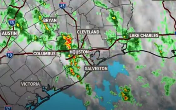
It’s rained 18 out of the last 24 days so the ground is very saturated and it won’t take much for ponding to form on our roadways.
HOUSTON — Keep the umbrella handy again today. We are starting the day wet and will end the day wet. There’s a 70 percent change of rain throughout the day, with temperatures staying in the 70s.
It’s rained 18 out of the last 24 days so the ground is very saturated and it won’t take much for ponding to form on our roadways.
> Watch KHOU 11 News at Noon for live updates
Flash Flood Watch
A Flash Flood Watch is in effect until 9 p.m. Austin, Coastal Brazoria, Fort Bend, Grimes, Inland Brazoria, Inland Harris, Montgomery, Waller and Washington counties.
A band of storms from the Freeport area are feeding up into Fort Bend and Harris counties and will continue to do so through early afternoon. Repeat rain through the day means rainfall totals of 2 to 3 inches in many areas. Isolated areas may see up to 6 inches.
Tuesday, the rain chances stay high at 60 percent. By Wednesday, rain chances drop down to about 30 percent, then high pressure moves in to keep the rain chances down and the temperatures start to rise leading into the Memorial Day weekend.
Watch Chita’s Monday morning update here:
Right now, long range models have us being spared any shower activity for Memorial Day itself. Stay tuned!