- Duke Energy prepares for potential power outages as severe weather nears the Triangle
- South Carolina wildfire grows to more than 2,000 acres, firefighters concerned about strong winds Tuesday
- Roof ripped off, damaged apartments, flipped over RVs: The DFW storm damage we saw
- Firefighters concerned about winds picking up Tuesday as South Carolina wildfire grows to more than 2,000 acres
- Central Texas prepares for wildfire threat with expanded response
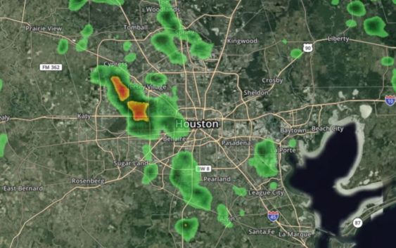
LIVE RADAR: Storms popping up; Flash Flood Watch expanded to northern counties

We could see more flash flooding today as rain pops up in the early afternoon hours — watch KHOU 11 News.
HOUSTON — We’re looking at another round of scattered, heavy downpours across the Houston area again on Tuesday.
Unlike Monday, today’s storms will mostly be a threat in the early afternoon hours. As of noon, we were watching heavy rain, especially north of Houston where a Flash Flood Watch has been expanded.
Northern counties added to Flash Flood Watch
Portions of south central Texas and southeast Texas, including the following counties, are under a Flash Flood Watch until 7 p.m. Tuesday: Austin, Brazoria Islands, Coastal Brazoria, Coastal Harris, Coastal Matagorda, Colorado, Fort Bend, Inland Brazoria, Inland Harris, Inland Matagorda, Matagorda Islands, Montgomery, Waller, Washington and Wharton. The watch was also expanded to include Brazos, Burleson, Grimes, Houston, Madison, Polk, San Jacinto, Trinity and Walker counties.
KHOU 11 Meteorologist Chita Craft warns we could see another 1 to 2″ of rain widespread today. If any of these downpours stall out or linger, then that rain total could go even higher.
“There could be isolated areas of street flooding, especially early this afternoon,” said Craft.
With the grounds still very saturated, we’re looking at a continuing Flash Flood Watch for much of the Houston region and Southeast Texas.
Some parts of town yesterday got more than 7″ of rain, especially on the city’s northeast side. And on the south side, flooding was reported along Highway 288. Thankfully, the high water spots there and on I-45 have since receded.
When will the rain go away?
Tuesday, the rain chances stay high at 80 percent, but we are starting the morning dry. While some parts of town, especially the northeast side, picked up more than 7″ of rain on Monday, Meteorologist Chita Craft says Tuesday we could pickup another 1 to 2″ widespread. Some areas could get more if the downpours stall out or “train” over the same region.
By Wednesday, rain chances drop down to about 30 percent, then high pressure moves in to keep the rain chances down and the temperatures start to rise leading into the Memorial Day weekend.
Right now, long-range models have us being spared any shower activity for Memorial Day itself.
Images from Monday’s flooding
As the ran fell, we saw plenty of photos and videos of high water, including this scene from Atascocita, where one person had to be rescued.
And Twitter user @PastorJaimeG captured these two videos of driving in high water. First, video from northeast Houston…
And going back to Atascocita, Barbara sent these photos showing the high water there.