- North Carolina legislators fleshing out details on $500M in additional Hurricane Helene relief
- Dangerous travel conditions: Ice, snow and flooding possible
- How photos lost in disasters like Hurricane Helene find their way home, with a little help from people who care
- Dangerous travel conditions, ice/snow and flooding possible in the mountains Tuesday and Wednesday
- Weather Impact Alert: Dangerous travel conditions, ice/snow and flooding possible in the mountains Tuesday and Wednesday
NC weather: Flash Flood Watch in effect; level 1 risk for severe storms Thursday
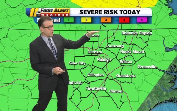
RALEIGH, N.C. (WTVD) — Severe storms could bring flooding to parts of central North Carolina later Thursday.
The entire region is under a level one threat for severe weather, according to the National Weather Service.
Heavy rain fell in spurts for several areas Wednesday. Parts of Wake County saw between 1-2 inches of rain–with one area in the western part of the county even registering as much as 6 inches!
In the next 24 hours, between 1-3 inches of rain is expected to fall across much of the region. That rain on top of an already saturated ground could cause flash flooding.
Click here to view the latest weather advisories.
Thursday’s storms will likely not pop up in the morning. But anytime from 12 p.m. on through Friday morning, you should be alert to the possibility of storms.
Wind gusts could get up to 45 miles per hour, which could prove dangerous by toppling some trees with shallow roots.
When the sun rises Friday things should dry up. However, there is another chance for scattered showers Friday afternoon.
Temperatures increase to the upper 80s and rain chances drastically decrease for the weekend.
Copyright © 2021 WTVD-TV. All Rights Reserved.