- Tuesday's wildfires scorched more than 500 acres in south Bexar County
- How big were this week's wildfires in Bexar County?
- Crews contain wildfire in southeast Williamson County
- Wildfire contained to 300 acres in northwest Matagorda County
- Bill would make it easier for homeowners to afford upgrades to protect from storm damage
Potential Tropical Cyclone 3 grows stronger; tropical storm force winds arrive on Gulf Coast
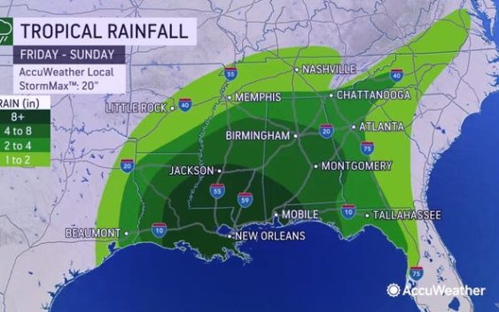
Potential Tropical Cyclone 3 is growing stronger as heavy rain and tropical storm force winds begin to reach portions of the northern Gulf Coast.
It is expected to become a tropical or subtropical storm later today before making landfall tonight or early Saturday.
Potential Tropical Cyclone 3 has maximum sustained winds of 45 mph, according to an advisory issued at 12 p.m. CT from the National Hurricane Center.
Tropical-storm-force winds extend outward up to 205 miles east of the center.
The circulation is gradually becoming better defined, and a tropical storm is likely to form over the north-central Gulf of Mexico later today or tonight.
Cone of uncertainty: See the latest graphic from the NHC
On the forecast track, the system will approach the north-central Gulf Coast tonight or early Saturday. A northeastward motion across the southeastern United States is likely after landfall through the weekend.
Potential Tropical Cyclone 3 is located 165 miles south of Morgan City, Louisiana, and is moving north at 15 mph.
A turn to the north to north-northeast is expected during the next day or so.
Satellite images: See latest satellite image from NOAA, for a clearer picture of the storm’s size

Latest data on Potential Tropical Cyclone 3
Here is the latest data on Potential Tropical Cyclone 3 pulled from the National Hurricane Center’s 12 p.m. CT advisory.
- Location: 165 miles south of Morgan City, Louisiana
- Maximum sustained winds: 45 mph
- Movement: North at 15 mph
- Pressure: 1,007 MB (millibars)
- When next advisory will be released: 4 p.m. CT
Spaghetti models: Track Potential Tropical Cyclone 3
Watches and warnings in effect
A tropical storm warning is in effect for:
- East of Morgan City, Louisiana to the Okaloosa/Walton County line Florida.
- Lake Pontchartrain, Lake Maurepas and metropolitan New Orleans
A tropical storm warning means that tropical storm conditions are expected somewhere within the warning area, in this case within 12 to 24 hours.
Residents elsewhere along the northern Gulf Coast should monitor the progress of this system.
What’s next?
We will continue to update our tropical weather coverage daily. Download your local site’s app to ensure you’re always connected to the news. And look at our special subscription offers here.