- One set of evacuation orders lifted in Caldwell County after wildfire contained
- 'We gutted every building' | Chimney Rock rebuilding after Hurricane Helene
- 'We gutted every building' | Chimney Rock rebuilding after Hurricane Helene
- Debris from Hurricane Helene provides fuel, complicates containment for spring wildfires
- David & Nicole Tepper increase Hurricane Helene relief commitment to $750k
Tropical Storm Claudette expected to form today, bring rain to NC early next week
RALEIGH, N.C. (WTVD) — The tropical system headed for the Gulf Coast could bring rain to North Carolina at the start of next week.
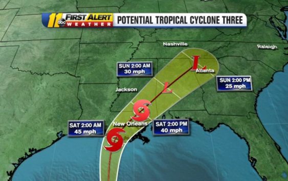
According to the National Hurricane Center, Potential Tropical Cyclone 3 is located about 300 miles south of Morgan City, Louisiana.
It has sustained winds of 35 miles per hour and is speeding up. It’s now moving north at about 14 miles per hour, which is good because the faster it goes the less rain it can drop in specific areas.
The storm has a 90 percent chance to become a tropical storm (in which case it would be named Claudette) sometime Friday. Whether it becomes Claudette or not doesn’t really change the forecast any.
“It’s pretty much semantics. The results are going to be exactly the same with some heavy rain,” ABC11 Meteorologist Steve Stewart said.
The storm system is expected to arrive in North Carolina late Sunday into early Monday, but where exactly it will be and how much rain it will bring still remains a matter of speculation.
Right now it appears that areas in the Sandhills will receive the bulk of the rain. Some weather models even keep the storm so far south that no rain at all reaches the Triangle.
We’ll have a better idea about where the rain late Sunday and early Monday will fall in the coming hours and days.
Copyright © 2021 WTVD-TV. All Rights Reserved.