- South and Midwest face potentially catastrophic rains and floods while reeling from tornadoes
- Deadly 2024 hurricanes prompt WMO to retire three names
- Body recovered in North Carolina identified as East TN man who has been missing ever since Hurricane Helene
- Report: Coastal flooding could threaten 1.4 million homes by midcentury
- Caught on camera | Tornado touches down in Missouri
Tropical Storm Claudette Spawns Tornadoes and Brings Heavy Rains to the South
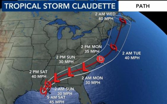
Tropical Storm Claudette, the third named storm of the Atlantic hurricane season, formed in the Gulf of Mexico and brought “copious rainfall” of 5-10 inches across the Mississippi Delta and Gulf Coast before being downgraded to a tropical depression Saturday, forecasters said.
Maximum sustained winds decreased to 35 mph, with higher gusts, the National Hurricane Center said Saturday afternoon. “Claudette is expected to weaken a little more tonight,” the center said in an advisory. “However, it is forecast to become a tropical storm again when it moves across the Carolinas Sunday night or early Monday.”
Claudette was expected to produce additional rainfall totals of 3-6 inches, with some pockets getting as much as 8 inches, across eastern Alabama, northern Georgia, the Florida Panhandle, and South and North Carolina, the center said.
Isolated 15-inch rainfall totals could be recorded in southeastern Louisiana, southern Mississippi, southern Alabama and the western Florida panhandle, it said.
On Saturday, Tillmans Corner, Alabama, reported nearly 5 inches of rain; Slidell, Louisiana, reported more than 9 inches; and Diamondhead, Mississippi, reported nearly 12 inches, the Weather Prediction Center said.
Claudette also brought tornadoes to portions of Alabama, Florida, Georgia and Mississippi on Saturday, the National Hurricane Center said.
A tornado in East Brewton, Alabama, about 80 miles northeast of Mobile, touched down around 7:30 a.m. Saturday, injuring three people, authorities said.
Gov. Kay Ivey said on Twitter that about 50 homes in a mobile home park in the area were destroyed.
It is not unusual for tornadoes to develop within a hurricane system, said Dennis Feltgen, a spokesperson and meteorologist with the center in Miami.
“You’ve got these bands of thunderstorms that are rotating around the center, and there is wind coming from all sorts of different directions, so they’ll spring up these tornadoes very quick,” he said.
The storm system caused power failures across the South, particularly in Florida, where more than 12,000 customers were without electricity as of Saturday morning, according to PowerOutage.us, which aggregates live power data from utilities.
“We’re continuing to feel the effects of severe weather due to TS Claudette across Northwest Florida,” said Kimberly Blair, a spokesperson for Gulf Power Co., which had about 3,400 customers without power early Saturday afternoon.
In Alabama, nearly 3,000 customers were without power Saturday afternoon, according to Alabama Power, which said it was assessing damage from Claudette. Tornados unrelated to Claudette also touched down in parts of Ohio and Indiana, where power failures affected more than 77,000 customers.
While the 2021 Atlantic hurricane season is just getting underway, many residents along the Gulf Coast are still recovering from a string of storms that battered the region last summer and fall. Seven named storms thrashed the Gulf Coast in 2020, including Eta, which slammed Florida twice, leaving tens of thousands without electricity and flooding beach communities.
Louisiana, one of the hardest-hit states, saw at least five storms, including Zeta and Hurricane Laura, which made landfall on the state’s coast as a Category 4 storm with 150-mph winds, destroying office buildings, a sky bridge, trees and power lines. The storm was also responsible for at least six deaths in the state.
In late May, a subtropical storm named Ana developed northeast of Bermuda, becoming the first named storm of the current hurricane season. It was the seventh year in a row that a named storm developed in the Atlantic before the official start of the season June 1. Ana was followed by Bill, which formed hundreds of miles off the coast of North Carolina earlier this week and became a tropical storm before being downgraded as it remained at sea.
Scientists with the National Oceanic and Atmospheric Administration forecast that there would be 13-20 named storms this year, six to 10 of which would be hurricanes, and three to five major hurricanes of Category 3 or higher in the Atlantic.
Last year there were 30 named storms, including six major hurricanes, forcing meteorologists to exhaust the alphabet for the second time and move to using Greek letters. It was the highest number of storms on record, surpassing the 28 from 2005, and included the second-highest number of hurricanes on record.
Hurricanes have become increasingly dangerous and destructive with each passing season. Researchers have found that climate change has produced storms that are more powerful and have heavier rainfall. The storms also have a tendency to dawdle and meander. A combination of rising seas and slower storms also make for higher and more destructive storm surges. This article originally appeared in The New York Times.