- Austin adopts new map that greatly expands area at risk of wildfire
- CenterPoint Energy accelerates infrastructure improvements ahead of hurricane season
- Carolina Hurricanes playoff tickets go on sale Thursday
- Ask the Meteorologist: Why do tornadoes target Tornado Alley, Dixie Alley?
- Nonprofit closes distribution site that aided thousands after Hurricane Helene
Tropical Storm Claudette threatens to bring heavy rain, possible flooding to the Gulf Coast
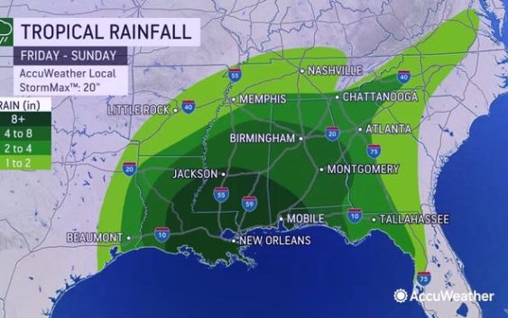
Tropical Storm Claudette continues to move north along the Gulf Coast and is expected to move further inland through parts of the southeastern U.S. through Sunday night.
Claudette has maximum sustained winds of 40 mph, according to an advisory issued at 1 p.m. CT from the National Hurricane Center.
The storm is expected to weaken into a tropical depression Saturday, but is forecast become a tropical storm again Sunday night or early Monday when it moves across the Carolinas.
Tropical-storm-force winds extend 205 miles southeast from the center.
Claudette is located about 80 miles northwest of Mobile, Alabama, and is moving north at 14 mph.
Cone of uncertainty: See the latest graphic from the NHC
Satellite images: See latest satellite image from NOAA, for a clearer picture of the storm’s size
A turn toward the northeast is expected later today, followed by a motion toward the east-northeast this evening or Sunday.

Latest data on Tropical Storm Claudette
Here is the latest data on Tropical Storm Claudette pulled from the National Hurricane Center’s 1 p.m. CT advisory.
- Location: 80 miles north of Mobile, Alabama
- Maximum sustained winds: 40 mph
- Movement: Northeast at 14 mph
- Pressure: 1,007 MB (millibars)
- When next advisory will be relased: 4 p.m. CT
Spaghetti models: Track Tropical Storm Claudette here
What’s next?
We will continue to update our tropical weather coverage daily. Download your local site’s app to ensure you’re always connected to the news. And look at our special subscription offers here.