- David & Nicole Tepper increase Hurricane Helene relief commitment to $750k
- David & Nicole Tepper increase Hurricane Helene relief commitment to $750k
- McDowell County wildfire spreads to 500 acres, evacuation orders in place
- Evacuations in Caldwell County due to wildfire
- Northwest Houston 'ghost neighborhood' caused by repeated flooding to become latest detention basin
Tropical Storm Watch issued for NC coast as Claudette nears landfall
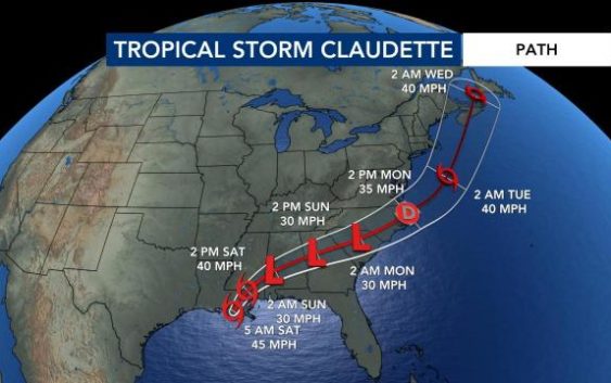
Raleigh, N.C. — Tropical Storm Claudette has formed in the Gulf of Mexico and is expected to bring rain and strong storms to parts of the southeast, including North Carolina.
Claudette formed early Saturday morning. The storm’s maximum sustained winds strengthened to 45 miles per hour on Friday night. The system is moving north-northeast at 12 miles per hour and was about 45 miles southwest of New Orleans at about 6 a.m.
Rain has begun falling along the Gulf Coast, and there is a high risk for flash flooding for some Gulf Coast states on Saturday. The storm will move across Mississippi, Alabama, Georgia and Florida producing heavy rainfall before the track turns east and weakens.
A Tropical Storm Watch has been issued for the North Carolina coast and most of the state’s coastline (from Cape Lookout to the Virginia border) could experience storm surge. Tropical storm conditions are possible Sunday night and Monday morning at North Carolina beaches.

“It took a while to name this as a tropical storm because it did not develop the center of circulation, but we are seeing that this morning” said WRAL meteorologist Peta Sheerwood.

The National Weather Service said the system is expected to produce heavy rain and flash flooding along the central Gulf coast. Tropical storm conditions are expected to start Friday from Intracoastal City, La. to western Florida. Those same conditions are possible along parts of the North Carolina coast on Sunday night and Monday.
The system is moving north on a path that could take it over Louisiana Saturday and across the southeast and into the mountains of western North Carolina by the end of the coming weekend.
Several models have the system going right over central North Carolina, meaning we could see heavy rain south and east of the track.
“By the time it gets to us, it would be a remnant low pressure system,” said WRAL meteorologist Kat Campbell.
The amounts will depend on the center of the system track. The timing of the rain looks to get here on Sunday evening, so get your Father’s Day plans in early. The rain looks to stick around on Monday morning before moving out on Monday afternoon.
There should be a break in the rain Monday night, but a cold front Tuesday will deliver another round of showers and thunderstorms.
Rainfall totals could reach 1.5 inches by Tuesday in the Triangle. The heaviest amounts of rain would appear in our southwestern counties with severe weather possible in the southeast half of the viewing area.

“Rain will be more impactful than wind, but we could see some gusts up to 35 miles per hour,” said Campbell, adding that the tornado threat will depend on the exact track of the system.
“Right now, it appears that if there is a risk – it will stay south of the Triangle,” added Campbell.
