- Fake job seekers are flooding the market, thanks to AI
- One set of evacuation orders lifted in Caldwell County after wildfire contained
- 'We gutted every building' | Chimney Rock rebuilding after Hurricane Helene
- 'We gutted every building' | Chimney Rock rebuilding after Hurricane Helene
- Debris from Hurricane Helene provides fuel, complicates containment for spring wildfires
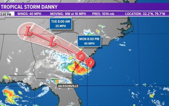
Tropics: Tropical Storm Danny. Warnings continue for South Carolina

Tropical Storm Danny will keep us on its southwest perimeter , producing downpours and some t-storms for us.
JACKSONVILLE, Fla. — The First Coast is feeling the impacts of Danny with frequent, scattered downpours this afternoon. The gustiest of the weather will remain north of our area, closer to where the center will be making landfall near Savannah and Hilton Head.
The main impacts for our area will be these gusty showers with minor, temporary, and localized flooding possible in the heaviest pockets. There is also a higher risk of rip currents. The rain will fade after 5 p.m. with the showers quickly shifting north, as TD 4 is making landfall, and fading after sunset.
As 3 p.m., Tropical Storm Danny’s center is currently about 45 miles east-southeast of Charleston, South Carolina. It is producing a large area of showers and thunderstorms mainly west of the center.
There is also a second area in the eastern tropical Atlantic we are keeping an eye on, far away from the First Coast, with a low chance of development. This system is a broad area of low pressure associated with a tropical wave. It’s been consistently producing a small cluster of showers and thunderstorms as it travels westward. Some slow development is possible through the end of the week while this system moves quickly at about 20 mph, likely reaching the Lesser Antilles by Wednesday night.
Hurricane season is here and the time to prepare is now. Make sure you have had conversations with your loved ones about what you would do if a storm were to threaten.
This year, NOAA released the new seasonal averages for the Atlantic basin. According to the 30-year data from 1991 to 2020, the new averages include 14 named storms, 7 hurricanes, and 3 major hurricanes. The previous Atlantic storm averages, based on the period from 1981 to 2010, were 12 named storms, 6 hurricanes, and 3 major hurricanes. The averages from 1951-1980 , were 11 named storms, 5 hurricanes, and 1 major.
Hurricane safety and preparedness is critically important before the season begins on June 1. NOAA’s National Weather Service provides resources to prepare for hurricane hazards and real-time updates about active weather systems from the National Hurricane Center at www.hurricanes.gov.
The Atlantic hurricane season officially runs from June 1 to November 30.