- Residents evacuate as wildfire rapidly spreads in South Bexar County
- Duke Energy prepares for potential power outages as severe weather nears the Triangle
- South Carolina wildfire grows to more than 2,000 acres, firefighters concerned about strong winds Tuesday
- Roof ripped off, damaged apartments, flipped over RVs: The DFW storm damage we saw
- Firefighters concerned about winds picking up Tuesday as South Carolina wildfire grows to more than 2,000 acres
Rainy Friday looms ahead of July 4th weekend; Tropical Storm Elsa forms
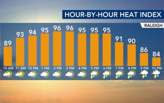
Raleigh, N.C. — Feelin’ hot, hot, hot
Sunshine, humidity and summer-like temps return full force this week – with forecasted highs in the 90s through Thursday, and heat indexes creeping up near 100.
Temperatures are starting off in the mid-70s before 5 a.m., warmer than where we were on Wednesday morning. By lunchtime, we’re looking at 88 and see a high of 92 with a heat index in the mid-to-upper 90s.
But there will be a significant pattern change ahead of the weekend as showers and thunderstorms drop in on us, starting on Thursday night. Friday will be rainy for most folks.
“This will be the beginning of a big change in our weather pattern,” said WRAL meteorologist Elizabeth Gardner. “In the summertime, we don’t often see rain all day-type events, but that is what we’re going to see [Friday].”

Saturday and Sunday should be nice days for the holiday weekend as humidity should drop somewhat behind the front.
4th of July planning
Mother nature may throw us some ‘natural fireworks’ for the July 4th weekend, with a chance for rain and storms. Be sure to keep an eye on WRAL Weather for updates on the weekend weather, so you can plan your celebrations accordingly.

“It’ll be less humid for July 4th, how often do you get to say that?” joked WRAL meteorologist Mike Maze. “85 is the high for the holiday,” he said.
If you’re heading to the coast for the holiday weekend you should see some nice weather after storms move through on Friday. Rain chances are high on Friday, but low on Saturday and nonexistent on Sunday and Monday, so make sure you pack the sunblock.
“Friday will be the wettest day of the week as a cold front moves through NC but the weekend is trending drier,” WRAL meteorologist Kat Campbell said.

And if you’re going in the ocean, be careful of dangerous rip currents, as they continue to plague swimmers. Lifeguards at Carolina Beach and Wrightsville Beach rescued 10 people Monday from rip currents.

Tropical Storm Elsa forms
Two new weather systems have developed out to sea and are projected to head toward the United States.
The first system became Tropical Storm Elsa on Thursday morning. Elsa will bring heavy rain across the Windward and southern Leeward Islands on Friday. The system is moving west at 25 miles per hour with winds as high as 40 miles per hour. Elsa is forecast to be near the Florida Peninsula early next week.

“We’ve got two systems that we’re watching and they’re both different than the one that moved into South Carolina yesterday, Danny is long gone,” WRAL meteorologist Kat Campbell said. “These are farther out in the Atlantic and both systems will continue to track to the west and northwest.”
Campbell says these systems are still days away from potentially making an impact on the U.S., but that if you’re planning any July 4 trips to the tropics, it’s something that may impact your travel.
“This system is likely to impact the Caribbean during the holiday weekend,” Campbell said. “As for the U.S., impacts are possible next week. The American model has impacts in the southeast at the end of next week.”
As of 11 p.m. Wednesday night, potential Tropical Cyclone 5 was upgraded to Tropical Depression 5.