- How photos lost in disasters like Hurricane Helene find their way home, with a little help from people who care
- Dangerous travel conditions, ice/snow and flooding possible in the mountains Tuesday and Wednesday
- Weather Impact Alert: Dangerous travel conditions, ice/snow and flooding possible in the mountains Tuesday and Wednesday
- North Carolinians perplexed by unexpected DMV refunds tied to Hurricane Helene relief
- Yes, NCDOT is sending Hurricane Helene relief checks
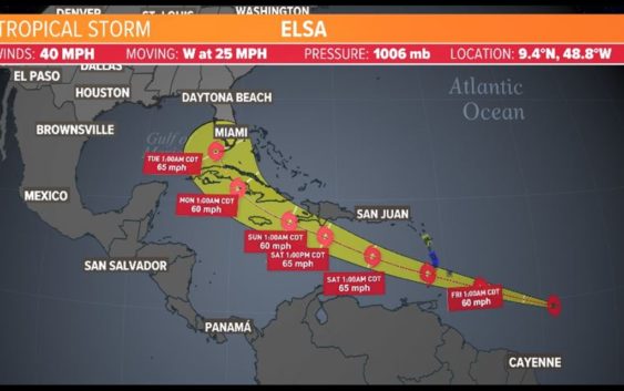
Tropical storm update: Elsa forms in Atlantic, could be heading for Gulf | View latest forecast

Here’s the latest from the KHOU 11 Weather Team and the National Hurricane Center.
HOUSTON — The KHOU 11 Weather Team is keeping a close eye on the tropics, and a system in the Atlantic has our attention.
The National Hurricane Center is issuing advisories on what is now Tropical Storm Elsa.
As of the 4 a.m. Thursday update, the forecast cone has Elsa entering the Gulf of Mexico by early next week and possibly turning toward Florida. KHOU 11 Meteorologist Chita Craft says a front should steer it east of Texas.
National Hurricane Center key messaging
1. Tropical storm conditions are expected beginning early Friday in portions of the Windward and southern Leeward Islands.
2. Heavy rainfall from the system will move quickly across the Windward and southern Leeward Islands, including Barbados, on Friday. Isolated flash flooding and mudslides are possible.
3. There is a risk of wind and rainfall impacts in portions of the Virgin Islands, Puerto Rico, Hispaniola, Cuba, the Turks and Caicos and the southeastern Bahamas through early next week. Interests in these areas should monitor the system’s progress and updates to the forecast.
4. Interests in Florida should monitor updates to the forecast for this system, but it is too soon to determine what if any impacts could occur there next week given the uncertainty in the long-range forecast.
TROPICAL STORM ELSA SPAGHETTI MODELS
TROPICAL STORM ELSA FORECAST CONE
A Tropical Storm Warning has been issued for Barbados, St. Lucia and Martinique. On its current path, the system is expected to pass over the islands on Friday, move into the Caribbean Sea on Friday afternoon or evening and then move near the southern coast of Hispanola on Saturday.
INTERACTIVE TROPICAL TRACKER
We should get a break from the heavy downpours on Thursday and Friday before they return Saturday and through the holiday weekend. The rain chances remain high early next week as well.
Follow our team on social media for the latest updates: