- 'We gutted every building' | Chimney Rock rebuilding after Hurricane Helene
- 'We gutted every building' | Chimney Rock rebuilding after Hurricane Helene
- Debris from Hurricane Helene provides fuel, complicates containment for spring wildfires
- David & Nicole Tepper increase Hurricane Helene relief commitment to $750k
- David & Nicole Tepper increase Hurricane Helene relief commitment to $750k
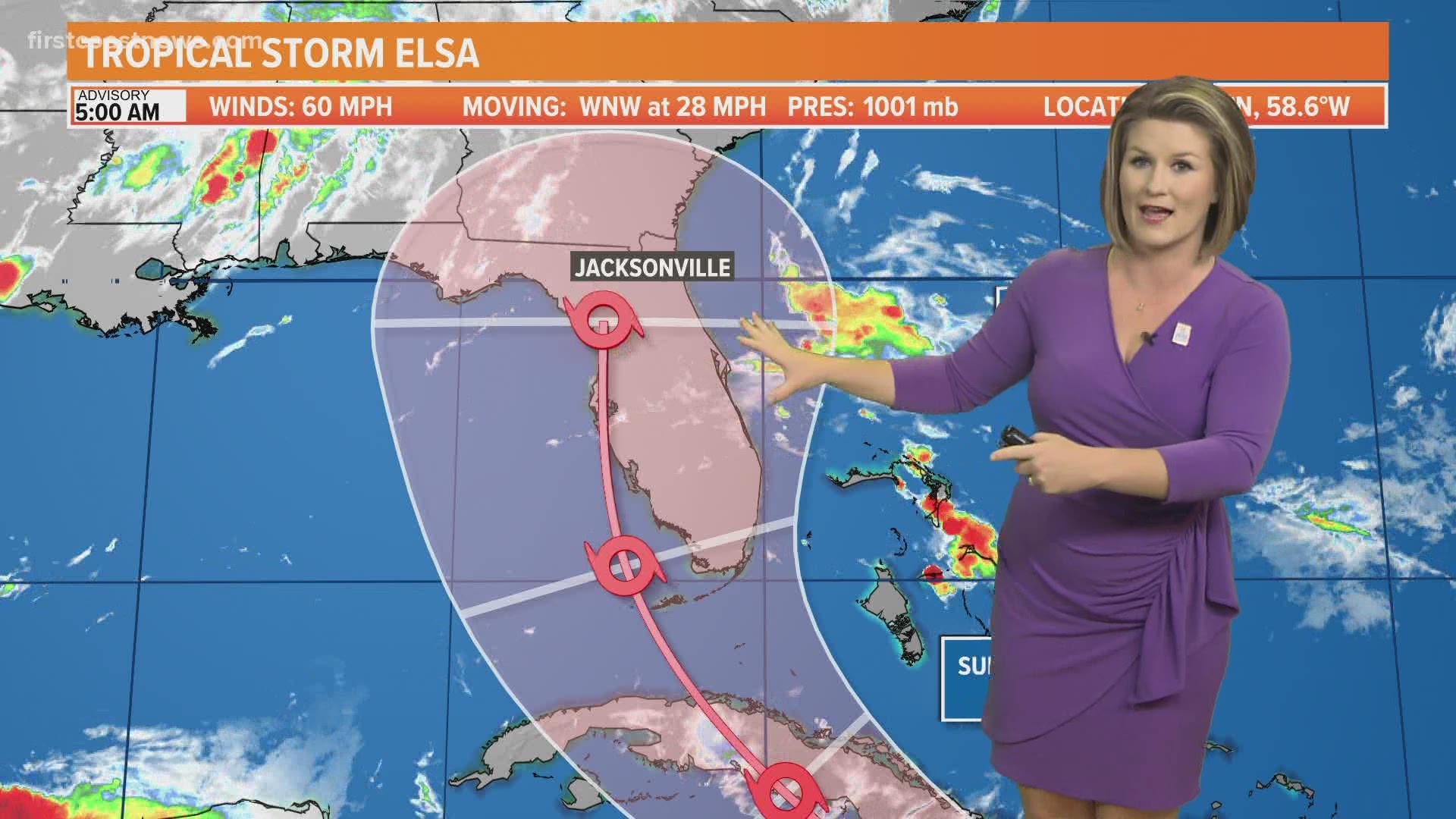
Hurricane Elsa: Latest projected path, models and potential impact to Florida

The state of Florida is included in the 5 day cone, but impacts, if any, are still very unclear. Continue to stay tuned for updates throughout the weekend.
JACKSONVILLE, Fla. — Tropical Storm Elsa has strengthened into a hurricane – the first hurricane of the 2021 Atlantic season. Impacts, if any, to the state of Florida or the United States, are still unclear. There remains a great deal of uncertainty on the intensity and track forecast in the long range as this system moves through the Caribbean. If this storm were to impact the First Coast, it looks to be Wednesday of next week. We will continue to fine-tune that forecast as Elsa’s story unfolds this weekend. Make sure to check in at least once a day for updates.
Elsa is the earliest-known fifth named storm on record for the Atlantic basin in the satellite era (1966-present), breaking the record formerly held by Edouard on July 6, 2020.
As of 7:45 a.m. on Friday: Elsa has strengthened into a hurricane, which is the first hurricane of the 2021 Atlantic hurricane season and is moving over the Lesser Antilles. Elsa’s center is moving near Barbados and is racing toward the west-northwest at 28 mph. Any impact to our area, if at all, will be after the weekend toward Wednesday.
Tropical Storm Elsa Cone, Computer and Spaghetti Models

In the short term, while Elsa moves across the warm Caribbean waters, some additional strengthening seems likely. However, the fast forward speed of the storm and associated mid-level wind shear should prevent significant intensification. Since the new forecast is a little stronger than the previous one and shows peak winds just below hurricane force on Saturday near Haiti, Tropical Storm Warnings have been issued for portions of the Dominican Republic and Haiti and a Hurricane Watch is now in effect for the southern portion of Haiti out of an abundance of caution. The degree of land interaction with the mountainous islands of Hispaniola and Cuba will be a big factor in the future strength of Elsa by late this weekend and early next week. Like the track forecast, there is a huge model spread with solutions ranging from dissipation in the Caribbean to a category 3 hurricane. Given the uncertainty, the intensity forecast generally keeps the storm steady in strength through the weekend, and it remains on the less intense side of the model guidance.
It should be noted that the average NHC track errors are 175 miles and 200 miles at days 4 and 5, respectively. Given the larger-than-normal uncertainty and because hazards will extend well away from the center of the storm, everyone is urged to not focus on the exact forecast points.
HAZARDS AFFECTING LAND:
WIND: Tropical storm conditions are expected in portions of the Windward and the southern Leeward Islands within the warning areas and possible in the watch areas later today. Tropical storm conditions are expected in the warning areas in the Dominican Republic and Haiti on Saturday, with hurricane conditions possible in southern Haiti. Tropical storm conditions are possible in Jamaica Saturday night or early Sunday.
STORM SURGE: A storm surge will raise water levels by as much as 1 to 3 feet above normal tide levels in areas of onshore winds along the southern coast of Hispaniola.
RAINFALL: Tropical Storm Elsa is expected to produce rainfall totals of 3 to 6 inches with maximum amounts of 10 inches today across the Windward and southern Leeward Islands, including Barbados. This rain may lead to isolated flash flooding and mudslides.
Over Puerto Rico, rainfall of 1 to 3 inches with localized amounts of 5 inches is expected late today into Saturday. This rain may lead to isolated flash flooding and minor river flooding, along with the potential for mudslides.
Across portions of southern Hispaniola and Jamaica, rainfall of 4 to 8 inches with isolated maximum amounts of 12 inches is possible Saturday into Sunday. This rain may lead to scattered flash flooding and mudslides.
Hurricane season is already here and it’s time to be prepared if you aren’t already. Make sure you have had conversations with your loved ones about what you would do if a storm were to threaten.
This year, NOAA released the new seasonal averages for the Atlantic basin. According to the 30-year data from 1991 to 2020, the new averages include 14 named storms, 7 hurricanes, and 3 major hurricanes. The previous Atlantic storm averages, based on the period from 1981 to 2010, were 12 named storms, 6 hurricanes, and 3 major hurricanes. The averages from 1951-1980 , were 11 named storms, 5 hurricanes, and 1 major.
Hurricane safety and preparedness are critically important before the season begins on June 1. NOAA’s National Weather Service provides resources to prepare for hurricane hazards and real-time updates about active weather systems from the National Hurricane Center at www.hurricanes.gov.
The Atlantic hurricane season officially runs from June 1 to November 30.
Download the First Coast News app and sign up for severe weather alerts
