- Austin leaders consider expanding wildfire protection plan
- Large hail, strong winds and tornado threat possible into Thursday evening
- Large hail, tornado threat possible Thursday evening
- Jaccob Slavin scores in OT as the Hurricanes beat the Capitals in Game 1 of their 2nd-round series
- 5 On Your Side: What happened to cars flooded during Hurricane Helene?
Hurricane Elsa moving quickly across Caribbean, NC in path

North Carolina is included in the path of Hurricane Elsa, the first named hurricane of the season.
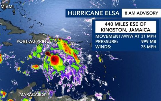
The 8 a.m. update from the National Hurricane Center showed the storm was 440 miles east-southeast of Kingston, Jamaica.
“It’s moving north and west,” said WRAL meteorologist Peta Sheerwood. “There’s quick movement with the storm.”
Top winds for the storm are currently at 75 miles per hour.
The storm, which is moving 31 miles per hour, is currently heading to Hispaniola and Cuba. The system is more disorganized compared to Friday.
“The reason why it’s moving so quickly is because of some stronger upper level-winds,” Sheerwood said. “But it’s also making the top of the storm become a little bit more disorganized.”
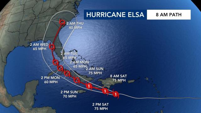
The latest forecast track from the NHC showed Hurricane Elsa continuing to move west-northwest and interacting with Cuba, before eventually making its way into the southeastern Gulf before making a turn.
“The storm has weakened slightly – with the forward motion – it’s going to have a hard time maintaining its integrity,” said WRAL meteorologist Mike Maze.
“If it does weaken a little bit more, this could influence the track as we head into Sunday and Monday,” Sheerwood said. “But if it stays over warmer sea surface temperatures, just south of Cuba, we could see this strengthen and the track could continue to change.”
If the storm does make its way to the state, it looks like the storm would be here on Thursday, according to Maze.
There are two things to watch with the storm:
“Upper-level wind shear is going to increase over the next 24-48 hours, which should weaken the storm, in theory. Also, with interaction of the land-mass [around Cuba] may further weaken it, so by the time it does get into the Gulf, it may be much weaker than it’s forecasted now,” explained Maze.
Maze added that the spaghetti model plots are now showing a more general consensus that the storm will head in the current forecasted direction.

