- Colorado State University predicts above-average 2025 Atlantic Hurricane Season
- South and Midwest face potentially catastrophic rains and floods while reeling from tornadoes
- Deadly 2024 hurricanes prompt WMO to retire three names
- Body recovered in North Carolina identified as East TN man who has been missing ever since Hurricane Helene
- Report: Coastal flooding could threaten 1.4 million homes by midcentury
Tropical Storm Elsa to re-strengthen, pass through NC

It’s looking more likely that Tropical Storm Elsa could have an impact in North Carolina in the coming days.
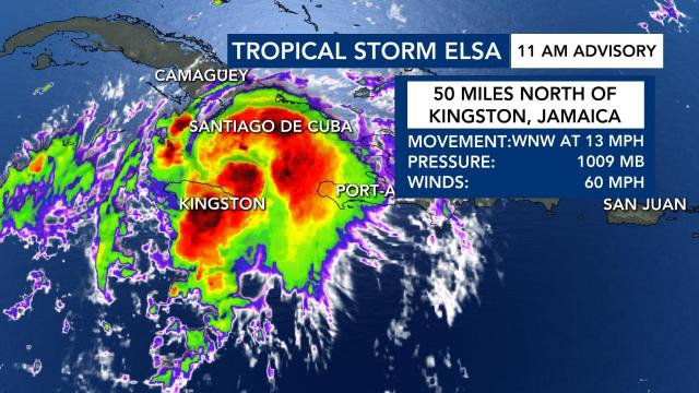
Sunday at 11 a.m., the latest update from the National Hurricane Center showed the storm was 50 miles north of Kingston, Jamaica.
Elsa is slowing down, according to WRAL meteorologist Peta Sheerwood, and moving west/northwest at 13 miles per hour.
“Yesterday morning, when we were talking about Elsa, it was moving at 31 miles per hour and the speed continues to slow down,” Sheerwood said. “It will likely continue to slow down as we head throughout the day.”
The system’s maximum sustained winds are down to 60 miles per hour, but we’re watching for a potential re-strengthening as the system makes its way over the Gulf of Mexico. The storm is expected to make landfall in Cuba heading into Monday and bring lots of rain.
A Tropical Storm Warning was issued for the Florida Keys.
“We’ll watch this system closely as land interaction from Cuba could cause some definite weakening, but re-strengthening should occur once Elsa moves away from Cuba and through the Florida straits,” said WRAL meteorologist Zach Maloch.
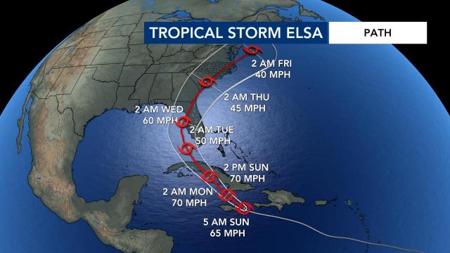
The latest forecast track from the NHC showed Hurricane Elsa continuing to move west-northwest and interacting with Cuba, before eventually making its way into the southeastern Gulf before making a turn. Many of the computer models have the system turning northeast once it makes contact with Florida, going into Georgia, South Carolina and North Carolina.
It the storm does weaken, it could influence the track as we head into Sunday and Monday, according to Sheerwood, but it it stays over warmer sea surface temperatures, just south of Cuba, we could see this strengthen and the track could continue to change.
The storm will begin moving through portions of the southeast United States beginning Wednesday, according to Maloch.
Elsa would be in North Carolina late Wednesday night, or early Thursday morning. Our state is in the forecast cone, but there’s uncertainty between now and then. We could see some gusty winds and heavy rains across eastern and central part of the state.
The storm would likely move away from the state by Thursday night, according to Maloch.
There are two things to watch with the storm:
“Upper-level wind shear is going to increase over the next 24 to 48 hours, which should weaken the storm, in theory. Also, with interaction of the land-mass [around Cuba] may further weaken it, so by the time it does get into the Gulf, it may be much weaker than it’s forecasted now,” explained Maze.
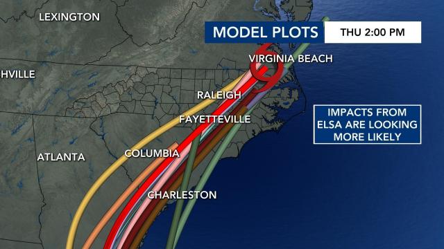
Maze added that the spaghetti model plots are now showing a more general consensus that the storm will head in the current forecasted direction.
“We are getting some very good agreement that some impact from Elsa is looking more likely for us here, in central North Carolina,” said Maloch.


