- One year after devastating Panhandle wildfires, Canadian resident reflects on the work of rebuilding
- Hays County judge says software glitch caused some communication issues during wildfires
- FEMA deadline for Hurricane Helene recovery aid to governments, nonprofits extended
- Sellers and Rantanen are among the NHL trade deadline winners. Hurricanes and Boeser are some losers
- Hurricane forecasters express concern over NOAA job cuts impact
TIMELINE: Outer bands of Tropical Storm Elsa begin to push into North Carolina
RALEIGH, N.C. (WTVD) — A weakened but resilient Tropical Storm Elsa drenched northern Florida and southern Georgia with heavy rain Wednesday, killing at least one person near the state line and threatening to maintain tropical storm intensity until it reaches New England.
To get the latest weather alerts sent straight to your phone, download the ABC11 mobile app
The National Hurricane Center said Elsa still packed 45 mph winds more than six hours after making landfall along Florida’s northern Gulf Coast. The storm’s center was near Savannah, Georgia, by 11 p.m. Wednesday.
Elsa seemed to spare Florida from significant damage, though it still threatened flooding downpours and possibly tornadoes. The coasts of Georgia and South Carolina were under a tropical storm warning Thursday. Forecasters predicted Elsa would remain a tropical storm into Friday, and issued a tropical storm watch from North Carolina to Massachusetts.
Authorities in Jacksonville, Florida, said one person was killed Wednesday when a tree fell and struck two cars. The National Weather Service reported 50 mph wind gusts in the city. The tree fell during heavy rains, said Capt. Eric Prosswimmer of the Jacksonville Fire Rescue Department. He said no one else was injured.
The hurricane center said parts of Florida could see up to 8 inches of total rain accumulation from the storm. There was also a risk of flooding in Georgia and South Carolina, which were predicted to get 3 to 5 inches of rainfall. Tornado watches were in effect in parts of northern Florida and southeast Georgia into Wednesday evening.
Scattered power outages were being reported along Elsa’s path Wednesday evening, with about 35,000 homes and businesses on either side of the Georgia-Florida state line without electricity, according to the website poweroutages.us.
Elsa is the earliest fifth-named storm on record, said Brian McNoldy, a hurricane researcher at the University of Miami.
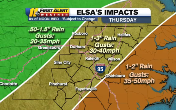
Elsa’s path is expected to go just west of Interstate 95 into and through North Carolina on Thursday. That is a western shift in Elsa’s path, tracking the center of the storm more directly over the Triangle.
Elsa will have weakened by the time it gets to North Carolina. It is expected to be a tropical depression when it arrives.
However, none of those changes to the forecast will cause any significant changes to the impacts our region will feel when Elsa arrives.
Elsa is expected to dump between 1-3 inches of rain (with isolated areas getting as much as 6 inches of rainfall) in central North Carolina and bring wind gusts as strong as 50 miles per hour in spots. Elsa also brings with it an isolated tornado threat.
Timeline
Showers could begin as early as 7 a.m. in the Sandhills on Thursday. As the day progresses, the rain spreads north across the ABC11 viewing area with the entire region seeing rain and storms by the afternoon.
Peak wind gusts Thursday will happened between 9 a.m. – 4 p.m. south of Wake County. Areas north of Wake County can expect the strongest winds between 11 a.m. – 7 p.m.
Elsa will move through North Carolina fairly quickly. The majority of the storm will be into Virginia by 9 p.m.
Friday will be partly cloudy with highs in the low 90s. The weekend looks mostly sunny with that heat remaining in the lower 90s.
North Carolina Preparations
The State Emergency Operations Center in Raleigh activated on Tuesday to monitor the storm.
“Residents and visitors to North Carolina should keep a close watch on the forecast for this storm,” Gov. Roy Cooper said in a statement on Tuesday. “It’s important that everyone be aware and prepared for rains, and it’s also important to avoid driving through floodwaters.”
The state’s emergency response team has reached out to local governments, making sure they have everything they need before Elsa arrives.
State leaders say individuals should also be sure they have everything they need in their emergency kits, including an evacuation plan and essential goods.
WATCH: What you need in your hurricane preparedness kit
Meanwhile, City of Raleigh is using an online system to automatically lower the water level at Johnson Lake.
The system lessens the amount of water flowing out of the dam down stream, leaving more room for the lake to fill up during a storm.
Before the installation of the automatic online system, City of Raleigh officials would have to go to Lake Johnson in person to open the valve.
Johnston County Public Schools announced that its Summer Learning Program would be canceled for students at all sites on Thursday, July 8. Friday, July 16 will serve as a makeup day.
All Durham Public Schools’ Summer programs were also canceled for Thursday.
The Associated Press contributed to this article.
Copyright © 2021 WTVD-TV. All Rights Reserved.