- Charlotte-based marketing agency announces $20,000 Creative Campaign Grant to help communities after Hurricane Helene
- Artists transform hurricane aftermath into hoop-inspired masterpieces at Charlotte exhibit
- NC's cost for Hurricane Helene damage is nearly $60 billion, state says
- State to develop drone program to better respond to disasters like Helene, Florence
- South Carolina residents face deadline to get storm debris out to the curb after Hurricane Helene
Tornado warning issued for Nash, Franklin as Elsa brings heavy rain, strong winds to NC
12 p.m.
The National Weather Service has issued a tornado warning for north-central Nash County and northeastern Franklin County until 12:30 p.m. A severe thunderstorm capable of producing a tornado was spotted over Nashville, moving northwest at 40 mph.
“This entire area, east of the Triangle, is a place we will be watching over the next couple of hours,” WRAL meteorologist Elizabeth Gardner said, noting an earlier warning had been issued for part of Wayne County.
11:45 a.m.
The National Weather Service has canceled the tornado warning for Wayne County. But flood advisories have been issued for Wayne, Johnston and Wake counties until 2:45 p.m. as Tropical Storm Elsa continues to dump rain across the region.
11:30 a.m.
Even after Tropical Storm Elsa moves on, some problems created by the storm’s rains could linger at the coast.
North Carolina environmental officials advised people on Oak Island to be aware of floodwaters being pumped to the ocean surf there. The town has pumped water from area streets into the ocean, and officials said the floodwater could contain pollutants such as waste from wildlife and pets, oil and gasoline from parking lots and waste from septic systems or sewers.
State officials will place signs at the discharge site along the beach to warn the public of the possible health risk, and the signs will be taken down 24 hours after the pumping stops.
11 a.m.
Tropical Storm Elsa is picking up speed as it moves across North Carolina. According to the National Weather Service, the system is moving northeast at 20 mph, up from 16 mph late Wednesday night.
Maximum sustained winds remain steady at 45 mph.
The storm has the potential for producing tornadoes, and the Weather Service issued a tornado warning for northeast Wayne County until 11:45 a.m. A severe thunderstorm over LaGrange was moving northwest at 40 mph, and WRAL meteorologist Zach Maloch said radar was showing rotating winds in the system that could develop into a tornado.
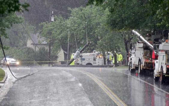
The heavy rain the storm is dumping across the region brought down a tree on Glen Eden Drive in west Raleigh, which snapped a utility pole in half. Police closed the road to traffic as utility crews moved in to start work on replacing the pole and restoring power to the area.
10:30 a.m.
North Carolina Gov. Roy Cooper has asked North Carolinians to avoid driving through flooded roads on Thursday as widespread rain continues to fall across the central and eastern parts of the state.
“Residents and visitors to North Carolina should keep safety in mind as Tropical Storm Elsa passes through our state today,” said Gov. Cooper. “Everyone should stay alert to rapidly changing weather conditions and have a plan should they need to move to another location.”
Earlier, there were crashes in Raleigh on Interstate 40 east and I-440 west.
The State Emergency Operations Center in Raleigh is tracking the storm.
10 a.m.
A Hope Mills woman had just spent the first night in her new home when she went to get a cup of coffee on Thursday morning. She returned to find a tree had fallen on her home and a fire truck had arrived.
“I thought the house was on fire,” Emmogene Perez told WRAL’s Gilbert Baez. “The firemen told me a tree had fallen on a powerline.”
Fortunately, no one was hurt and the tree did not break through the ceiling of the bathroom. Perez, who said she was originally from North Carolina, had just moved back. Her home still had power.
Parts of southern North Carolina have already seen multiple inches of rain from Elsa, making the ground saturated and thus ripe for trees falling down. Elsa’s center was near the state border around 10 a.m.
9:30 a.m.
The Triangle is seeing lots of heavy rain as Elsa moves northward, with the center of the storm expected to come through the Triangle around 2 p.m.
“On the back edge of that, things will really quiet down,” WRAL meteorologist Elizabeth Gardner said. “All the action with this is to the east or the north of the center.”
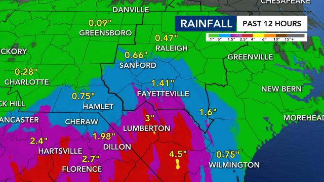
We’ve seen lots of rain to our south. Fayetteville has already seen nearly 1.5 inches of rain from Elsa. Lumberton’s rainfall estimate is 3 inches.
“It’s pouring there right now,” Gardner said of Fayetteville.
9 a.m.
Although much of the viewing area is seeing rain, the heaviest rain is hitting the southern counties right now, including Fayetteville. A tornado watch is still in effect in nine counties. A Flash Flood Watch is still in effect for all of the Triangle.
“This storm is really dumping a lot of heavy rain,” Gardner said. “Certainly, there’s going to be a lot of places where there’s going to be pockets of 3 to 4 [inches] and pockets of 5 which could cause some flooding.”
A tornado warning has popped up in Brunswick County, near Wilmington, in eastern North Carolina.
8:30 a.m. update
Many of our eastern counties are now under a Tornado Watch.
The counties added to the watch include Cumberland, Johnston, Harnett, Hoke, Nash, Wilson, Wayne, Sampson and Duplin.
“These brief spins of tornadoes are possible with these tropical systems,” WRAL meteorologist Zach Maloch said. “Tornadoes are a concern.”
A Flood Advisory was issued for Cumberland, Sampson and Hoke counties until noon.
8 a.m. update
Tropical Storm Elsa’s center is about 175 miles southwest of Raleigh as of 8 a.m. and is still moving fast at 18 mph to the northeast. Wind speeds are still at 40 mph. It’s raining steadily across the Triangle now.
The heaviest rain in the Triangle will last from about 10 a.m. to 2 p.m., according to Gardner. Elsa should maintain the strength of a weak tropical storm when it gets to central North Carolina. The storm’s elements should move out of the Triangle by late afternoon.
The main threats from Elsa continue to be heavy rain, gusty winds and the possibility for tornadoes. Some of Elsa’s rain bands have very heavy rain and have already dumped three inches in Robeson County.
A tornado warning was issued for an area near Myrtle Beach earlier.
6:15 a.m. update
A tornado warning was issued for Robeson County until 6:45 a.m.
5 a.m. update
Elsa’s winds have decreased in speed to 40 mph. The storm is moving quickly, heading northeast at 18 mph. The eye of the storm is 223 miles southwest of Raleigh.
The system is moving south to north as rain bands are moving into the Sandhills and southeastern North Carolina first. Rain will get into the Triangle in the 6 a.m. hour.
“We like to see these storms moving fast,” said Gardner. “The faster they go, the less time they sit and dump heavy rain on us. That means less flooding, less time for there to be wind damage.”
2. a.m. (Thursday) update
Elsa’s maximum sustained winds remain at 45 mph as the center of the storm is 286 miles southwest of Raleigh. It’s moving north at 18 mph. Rain from the system is moving steadily toward North Carolina.
A Flash Flood Watch is in effect for most of the viewing area from 6 a.m. through 6 p.m. Thursday. Elsa is expected to bring gusty winds and rain to the North Carolina/South Carolina border around 6 a.m. Most folks in the Triangle will start seeing rain by mid-morning.
Elsa’s eye will move through the Triangle in the early afternoon hours and move out by 6 p.m.
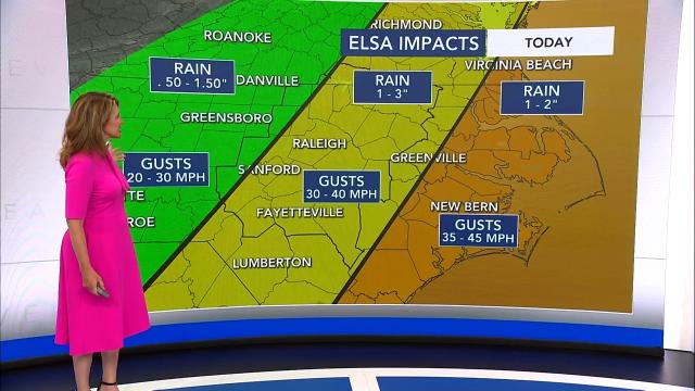
The Triangle should see wind gusts from 30 to 35 mph with 1 to 3 inches of rain possible. Stronger wind gusts are expected along and east of Interstate 95.
A Tornado Watch is in effect for Bladen, New Hanover, Columbus, Brunswick and Pender counties until 9 a.m.
There were tornadoes in Georgia and South Carolina after Elsa moved through.
11 p.m. (Wednesday) update
Tropical Storm Elsa is sustaining 45 mph winds and is now 329 miles SW of Raleigh. The storm is moving north, northeast at 16 mph.
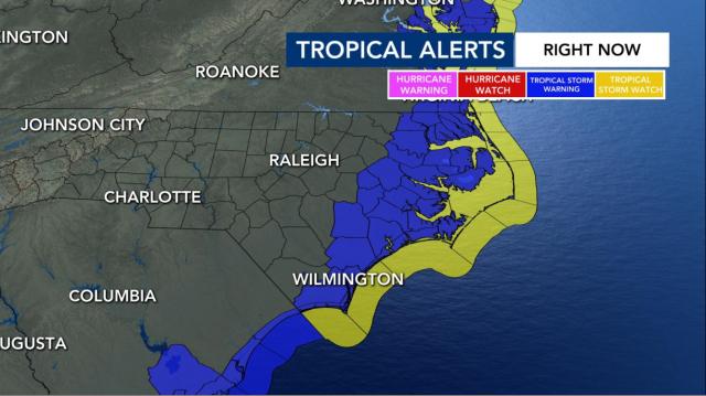
A Tropical Storm Warning was also issued for parts of the NC coast as the storm creeps closer.
“Elsa remains a tropical storm tonight as it moves through Georgia with 45 mph winds,” WRAL meteorologist Kat Campbell said. “The biggest update with the new track is that it is forecast to move through NC as a weak tropical storm (winds 40 mph) instead of a tropical depression.”
Campbell added that parts of Georgia and South Carolina are under a tornado watch until 5 a.m. Thursday.
“I wouldn’t be surprised if that watch gets extended into parts of eastern NC tomorrow,” she said. “We’re under a Level 1 risk.”
NC residents across the WRAL viewing area made final preparations for Elsa’s arrival Wednesday. From Rocky Mount to Wrightsville Beach, residents and visitors are keeping an eye on the storm.
8 p.m. update
Because of the possibility of inclement weather, Durham Public Schools has canceled all summer programs for Thursday.
Tropical Storm Elsa is moving 14 miles per hour over southern Georgia, according to the 8 p.m. update from the National Hurricane Center.
The system, which has maximum sustained of 45 miles per hour, is currently 283 miles southeast of Raleigh.
5 p.m. update
The 5 p.m. update from the National Hurricane Center showed that Tropical Storm Elsa has weakened even more as it moved into southern Georgia on Wednesday.
The system currently has maximum sustained winds of 45 miles per per. The storm continues moving at 14 miles per hour.
Elsa will move northeast overnight as it moves into North Carolina.
A flash flood watch was issued for parts of central North Carolina from 6 a.m. to 6 p.m. on Thursday, in anticipation of heavy rain. One to three inches of rain are possible, with isolated totals of four to five inches of rain. River flooding is not expected with Thursdays’ heavy rains.
WRAL meteorologist Mike Maze said Elsa is still expected to pass through North Carolina as a tropical depression on Thursday.
In the Triangle, wind gusts are expected to be 30 to 40 miles per hour.
WRAL meteorologist Kat Campbell said that while central North Carolina will see the heaviest rain from the storm, North Carolina’s coast – which is under a tropical storm watch – is expected to see the stronger winds and could see wind gusts up to 45 miles per hour.
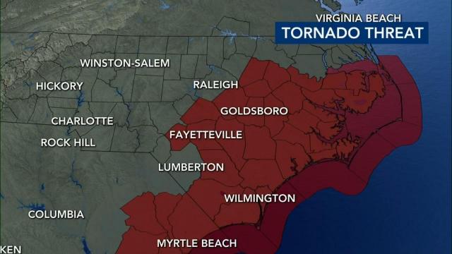
A shift west in Elsa’s forecast track during the 2 p.m. update caused the tornado threat is increase across the Triangle. The Triangle and points east of Interstate 95 will be under a threat for isolated tornadoes from 9 a.m. to 4 p.m.
Elsa has already spawned tornadoes in the Jacksonville, Fla. area on Wednesday.
The rip current risk will also continue to be moderate to high along the North Carolina coast this week.
2 p.m. update
Tropical Storm Elsa continued to weaken as it moved over northern Florida, according to the 2 p.m. update from the National Hurricane Center.
The storm currently has maximum sustained winds of 50 miles per hour.
WRAL meteorologist Mike Maze said Elsa is moving over the Florida Panhandle and south Georgia at 14 miles per hour.
Elsa, which is currently 471 miles southwest of Raleigh, is still expected to hit North Carolina as a tropical depression, according to the latest update.
Rain bands from Elsa are expected to be on the North Carolina/South Carolina border starting at 5 a.m. on Thursday. Then, Fayetteville will begin to see rain at 8 a.m. and the Triangle at 9 a.m.
The majority of heavy, widespread rain will be from 8 a.m. to 4 p.m. But, light showers will continue to remain possible until 8 p.m.
11 a.m. update
Elsa made landfall along the North Florida Gulf Coast on Wednesday morning, arriving in Taylor County.
The National Hurricane Center’s 11 a.m. update says Elsa is moving north at 14 mph with maximum sustained winds at 65 mph. Elsa is now forecast to impact North Carolina Thursday as a strong Tropical Depression.
A weakened Elsa dumped rain across Florida’s northern Gulf Coast early Wednesday but appears to have spared the state significant damage and widespread power outages.
The NHC issued a Tropical Storm Watch for North Carolina’s coastal areas initially before the watch was extended west to some inland counties on Wednesday morning. Swells of five to eight feet are possible, along with tropical storm force winds.
By Thursday morning, rain from Elsa arrives in the southern counties of central North Carolina, including Scotland and Richmond. The storm track brings it across North Carolina just southeast of Raleigh as a tropical storm before an eastward turn takes it back out over the Atlantic Ocean.
The forecast cone shows the storm could cross North Carolina anywhere from the Triad to the coast.
The rip current threat will also be high to moderate along the North Carolina coast on Wednesday.
“We could have some wind gusts up to 40 miles per hour and perhaps some isolated tornadoes as well,” said WRAL meteorologist Aimee Wilmoth.
The storm also presents a significant flooding risk, largely east of the Triangle. Most of eastern North Carolina is under a medium risk for flooding.
The biggest concern will be flooding with 1 to 3 inches of rain likely, and localized 4 to 5 inches possible. The good news is that river flooding is not expected, according to WRAL meteorologist Kat Campbell.
