- How photos lost in disasters like Hurricane Helene find their way home, with a little help from people who care
- Dangerous travel conditions, ice/snow and flooding possible in the mountains Tuesday and Wednesday
- Weather Impact Alert: Dangerous travel conditions, ice/snow and flooding possible in the mountains Tuesday and Wednesday
- North Carolinians perplexed by unexpected DMV refunds tied to Hurricane Helene relief
- Yes, NCDOT is sending Hurricane Helene relief checks
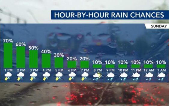
Thunderstorms and flooding threaten evening commute
A flood advisory in effect west of the Triangle has been expanded to include Wake and Franklin counties.
Wake, Durham, Chatham, Orange, Alamance, Franklin, Granville and Vance counties are under a flood advisory until 3:30 p.m. Monday as rain soaks the Triangle.
Download the WRAL Weather App for alerts and more
WRAL meteorologist Elizabeth Gardner said the rain is expected to become heavier around lunchtime, tapering off around 5 p.m. in the Triangle and later for our southern counties.
“Just expect this to continue for most of the day,” said Gardner.
The National Weather Service indicated up to 2 inches of rain already fell in the affected areas and more rain could lead to isolated flooding this afternoon. Drivers should take care to avoid flooded streets if they are out Monday afternoon.
There will be some lightning and thunder in the afternoon, but the biggest impact will likely be heavy rain creating a possibility of flooding, Gardner said.

Track rain with DUALDoppler5000
According to Gardner, the rain will stall to our south, bringing another chance for rain Tuesday. Between 2 and 3 inches of rain will be possible south of the Triangle.
Storm chances will keep temperatures slightly cooler, with highs in the upper 70s on Monday. Tuesday will also be warmer, with a high in the low 80s.
