- Trump makes more debunked claims about FEMA as he surveys storm damage in North Carolina
- Hundreds rescued, sheriff stranded on truck roof after deadly flooding in New Mexico
- In North Carolina, Trump and Harris navigate a hurricane and a rollercoaster governor’s race
- In North Carolina, Trump and Harris navigate a hurricane and a rollercoaster governor's race
- Family of Tennessee employee who died in Hurricane Helene flooding files wrongful death lawsuit
Heavy storms, additional flooding possible tonight

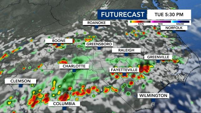
Raleigh, N.C. — More rain could hit our state Tuesday afternoon and evening. Showers will likely hit the Triangle around 4 p.m.
Thunderstorms dumped between 3 and 5 inches of rain in areas south and east of the Triangle overnight. The heaviest rain fell in Wayne and Sampson counties around 4:30 a.m. Parts of Johnston County and Harnett County saw flooded roads overnight and Flash Flood Warnings were issued. By 7 a.m., most of the rain was leaving the area.
That downpour could happen again on Tuesday, WRAL meteorologist Mike Maze said.
“I wouldn’t be surprised if some storms were strong and dump heavy rain,” he said.
A cold front will pass through North Carolina, bringing us the shot at rain. If Wilson, Johnston, Harnett, Sampson and Wayne counties see rain on Tuesday, that could cause flooding given the amounts they saw overnight.
“These are likely to be slow-moving and could produce heavy rain leading to localized flooding,” WRAL meteorologist Kat Campbell said. “Highs will be in the upper 80s to near 90 but it will feel more like 100 degrees when you factor in the humidity.”
Once the cold front drops in from the north, it will be aided by some upper-level energy to bring about widespread showers.
Over the next three days, central North Carolina could pick up at least half-an-inch to an inch and a half of rain.
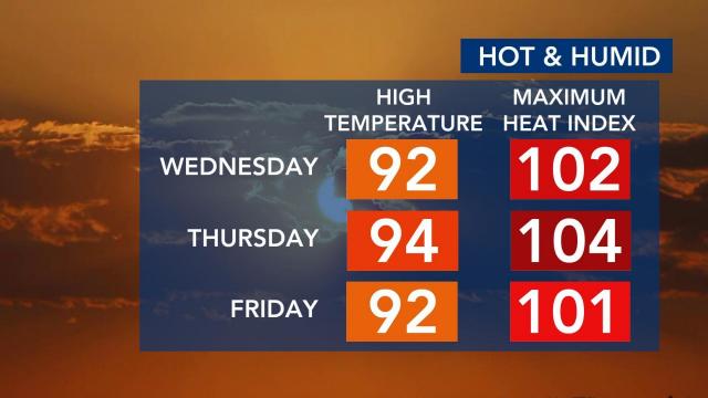
After storms move out of the area, it will get hot. We’re going to feel some of the hottest weather we’ve seen this summer. Starting on Wednesday, temperatures will feel much hotter, with a heat index over 100 degrees. Make sure to stay hydrated, and limit your time outdoors if possible.
“We’re going to see another hot afternoon [Tuesday] with the heat index climbing into the upper 90s,” WRAL meteorologist Elizabeth Gardner said. “Our actual high temperature will be in the high 80s like it was yesterday.”
The hottest segment of the year to this point was May 26-28, but it looks like this period could be hotter.
“The hottest stretch as of yet was back on May 26-28th and it looks like this could be a hotter stretch,” said WRAL meteorologist Aimee Wilmoth.
Wilmoth said by this time in 2020 we had experienced 10 days at 95 degrees or hotter. We have yet to hit 95 yet in 2021. Thursday could come close.
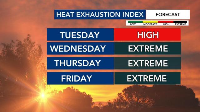
Our heat exhaustion index will reach the extreme category starting Wednesday.


