- One year after devastating Panhandle wildfires, Canadian resident reflects on the work of rebuilding
- Hays County judge says software glitch caused some communication issues during wildfires
- FEMA deadline for Hurricane Helene recovery aid to governments, nonprofits extended
- Sellers and Rantanen are among the NHL trade deadline winners. Hurricanes and Boeser are some losers
- Hurricane forecasters express concern over NOAA job cuts impact
Parts of central NC under Level 2 risk for severe weather as dangerous heat moves in

Raleigh, N.C. — Much of central North Carolina is under a Level 1 or Level 2 risk for severe weather Wednesday as we enter a brutal three-day stretch of heat with some of the hottest temperatures of this summer so far.
Storms on Wednesday will be isolated in nature, but any storms that do form could become severe with damaging wind gusts, according to WRAL meteorologist Aimee Wilmoth.
Storms could pop up late Wednesday afternoon and through the evening commute, and severe weather is more likely east and south of the Triangle.
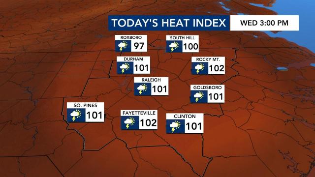
Starting on Wednesday, temperatures will also feel much hotter, with a heat index over 100 degrees. Make sure to stay hydrated and limit your time outdoors if possible.
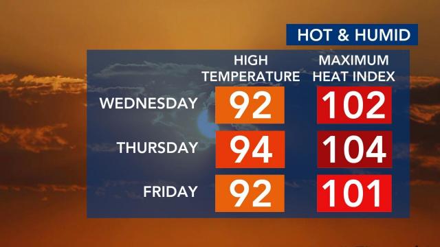
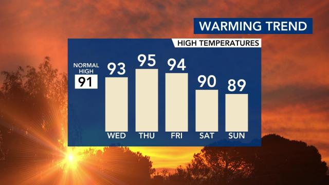
Heat index temperatures could lead to heat exhaustion. We were already in the mid 70s on Wednesday before 5 a.m. The high will be around 93 with a heat index of 101.
There is a slight chance of a thunderstorm in the early afternoon. Some isolated storms are possible south and east of the Triangle.
“Anything you need to do outside, you need to do as early as you can,” said WRAL meteorologist Elizabeth Gardner. “It’s one of those days you walk out the door and it feels like someone threw the wet blanket over you.”
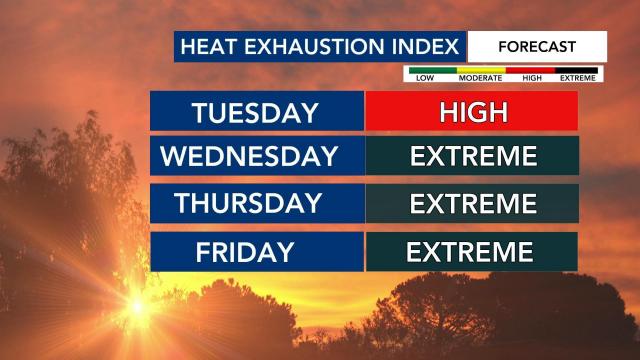
Maze says the heat exhaustion levels for Wednesday and Thursday are “extreme.”
Thursday, which could be the hottest day of the year so far, carries a high of around 95 and a sweltering heat index of 104.
The hottest segment of the year to this point was May 26-28, but it looks like this period could be hotter.
“The hottest stretch as of yet was back on May 26 through 28 and it looks like this could be a hotter stretch,” said WRAL meteorologist Aimee Wilmoth.
Wilmoth said by this time in 2020 we had experienced 10 days at 95 degrees or hotter. We have yet to hit 95 yet in 2021. Thursday could come close.
Our heat exhaustion index will reach the extreme category starting Wednesday. Friday’s heat index will be in the 100s as well.
As for when we could see relief? Temperatures could drop over the weekend and into the beginning of next week. The 80s could return with a dip in the jet stream.


