- Mexico sends firefighters to aid in fight against Los Angeles wildfires
- Bexar County crews send resources to assist efforts to combat wildfire scorching South California
- Mexico sends firefighters to aid in fight against Los Angeles wildfires
- San Antonio bakery to donate proceeds from new item to California wildfire victims
- Firefighters from San Antonio area deploy to fight California wildfires
Tropics: Disturbance in the Caribbean likely to soon become Tropical Storm Fred

Tropical Storm Warnings are in effect for Puerto Rico, the U.S. Virgin Islands, and a portion of the Dominican Republic.
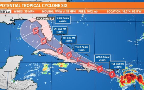
JACKSONVILLE, Fla. — The National Hurricane Center began issuing advisories for Potential Tropical Cyclone Six on Monday. This system is expected to develop into a tropical storm on Tuesday and may impact the First Coast by late this weekend into early next week. The extent of those impacts is still unclear, but we will continue to fine-tune the forecast day by day. Overall, the Jacksonville area can expect an increase in storm coverage with a flood threat due to recent, heavy rains and saturated grounds. Any additional rainfall would prolong river flooding as well.
Now is the time to stock up on supply kits and review your family’s emergency plan, especially with the most active part of the Atlantic hurricane season getting underway.
As of the 11 a.m. advisory on Tuesday, the disturbance was moving across the northeastern Caribbean Sea. It was about 220 miles east-southeast of Ponce, Puerto Rico, and was moving west-northwest at 18 mph. Based on surface observations from the islands and data from the Hurricane Hunters, the system still does not have a well-defined circulation. Although the satellite appearance shows some increase in organization, the surface data suggest no significant strengthening has occurred thus far.
Looking deeper into the season, the Climate Prediction Center has issued a La Niña Watch with La Niña potentially emerging from September through November. La Niña can help make atmospheric conditions more conducive for tropical cyclones to form the Atlantic, and less conducive in the Eastern Pacific. If 2021 is any indicator so far of what lies ahead this season, it could continue to be an active year. As of the beginning of July, there have been five named storms breaking the previous record set just last year. In August, the Climate Prediction Center will issue an updated hurricane outlook.
Hurricane season is here and it’s time to be prepared if you aren’t already. Make sure you have had conversations with your loved ones about what you would do if a storm were to threaten.
This year, NOAA released the new seasonal averages for the Atlantic basin. According to the 30-year data from 1991 to 2020, the new averages include 14 named storms, 7 hurricanes, and 3 major hurricanes. The previous Atlantic storm averages, based on the period from 1981 to 2010, were 12 named storms, 6 hurricanes, and 3 major hurricanes. The averages from 1951-1980 , were 11 named storms, 5 hurricanes, and 1 major.
Hurricane safety and preparedness are critically important even before the season begins on June 1. NOAA’s National Weather Service provides resources to prepare for hurricane hazards and real-time updates about active weather systems from the National Hurricane Center at www.hurricanes.gov.
The Atlantic hurricane season officially runs from June 1 to November 30.
Download the First Coast News app and sign up for severe weather alerts