- Asheville's resilient lodges welcome back travelers after Hurricane Helene
- Austin leaders consider expanding wildfire protection plan
- Large hail, strong winds and tornado threat possible into Thursday evening
- Large hail, tornado threat possible Thursday evening
- Jaccob Slavin scores in OT as the Hurricanes beat the Capitals in Game 1 of their 2nd-round series
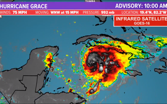
Grace strengthens to hurricane with 75 mph winds; Landfall expected near Cancun, Cozumel

A hurricane warning is in effect for the Yucatan Peninsula of Mexico from Cancun to Punta Herrero, including Cozumel.
HOUSTON — The KHOU 11 Weather team and National Hurricane Center are tracking three different systems in the tropics right now — Hurricane Grace, Post Tropical Storm Fred and Tropical Storm Henri.
Hurricane Grace
Grace strengthened to a hurricane Wednesday morning just west of the Grand Cayman, according to the National Hurricane Center.
A hurricane warning is in effect for the Yucatan Peninsula of Mexico from Cancun to Punta Herrero, including Cozumel.
It has maximum sustained winds of 75 mph but is expected to strengthen before making landfall late Wednesday or early Thursday.
Grace could cause flooding in the Cayman Islands and Jamaica Wednesday and mudslides in Jamaica.
The NHC confirmed the Hurricane Watch for the Cayman Islands has been canceled.
A lot can change, so we’re keeping a close eye on it.
Where is Grace going:
An almost due west course is set for Grace as it tracks towards the Yucatan by tomorrow morning. This track is heavily influenced by a building ridge over the northern Gulf of Mexico steering the storm westwards.
This will also act to prevent Grace from turning north and threatening the United States.
After landfall near Cozumel and Cancun, the storm will weaken briefly before re-remerging into the Bay of Campeche where it will make another run at deepening. It’s final landfall will be along the central Mexican coastline, mountainous terrain lies just inland so the storm will rapidly dissipate by the weekend,
Key messages for Grace
- Hurricane conditions and a dangerous storm surge are expected over portions of the Hurricane Warning area in the eastern Yucatan Peninsula of Mexico beginning late Wednesday night.
- Heavy rainfall across Jamaica, the Cayman Islands and the Yucatan Peninsula is likely to lead to flash and urban flooding. Mudslides are possible in Jamaica.
- Tropical storm conditions are expected over portions of Jamaica Tuesday night and over the Cayman Islands on Wednesday. Hurricane conditions are possible in the Cayman Islands by Wednesday morning. Tropical storm conditions are expected to spread westward from portions of Cuba in the warning area to, possibly, other portions of the southern coast of Cuba in the watch area Tuesday night.
Tropical Depression Fred
Fred made landfall along the Florida panhandle Monday afternoon with max winds of 65 mph. The storm is now weakening over land with a heavy rain and tornado threat across the east coast.
Tropical Storm Henri
Henri has maximum sustained winds near 65 mph with higher gusts.
Henri is currently just southeast of Bermuda. The storm will do a loop around the island before heading out to sea.
Some additional strengthening is forecast during the next couple of days.